Aircraft Meteorological Observation for Tropical Cyclones - Current and Future
|
The Observatory has been in close collaboration with the aviation community to collect meteorological observations for enhancing our weather services. In recent decades, investigation flights were conducted to study the low-level windshear and turbulence effects around the airport in Chek Lap Kok (link: http://www.hko.gov.hk/en/blog/00000124.htm). In 2009, the Observatory commenced regular flight data collection with the Government Flying Service (GFS). A fixed-wing aircraft Jetstream-41 of GFS was equipped with a dedicated meteorological measuring system to provide horizontal and vertical winds, temperature, pressure and humidity at a high frequency of 20 times per second. These high resolution data are used to enhance the turbulence alerting algorithms of the Windshear and Turbulence Warning System (WTWS) as well as to verify the windshear and turbulence alerts provided by the ground-based meteorological systems. In 2011, our cooperation with GFS extended to reconnaissance flights to capture weather data for tropical cyclones (TCs) over the South China Sea (Figure 1). This greatly enhances our capacity in monitoring the location and intensity of TC that have been based on limited observations or satellite pictures. To further enhance meteorological data collection in TC situation, HKO and GFS have planned to implement a launcher on the replacement GFS aircraft to release a measuring instrument called dropsonde. Similar dropsonde measurement programmes have been under real-time research operation over the western north Pacific and the Atlantic Ocean (http://www.eol.ucar.edu/isf/facilities/dropsonde/gpsDropsonde.html). A dropsonde consists of a set of weather sensors hanged under a mini-parachute. As the dropsonde descends, it measures weather data for transmission to the Observatory via the aircraft. This would provide the vertical meteorological profile of the atmosphere near the TC, and more importantly the near sea-surface wind information for better determination of the storm intensity. It would be safer to do the measurements as the aircraft can release the dropsondes on a higher altitudes and leave immediately without confronting the severe convection associated with the TC. |
|
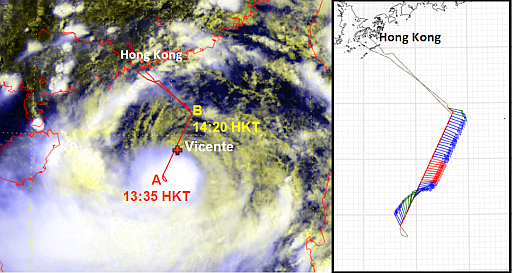
Figure 1 The flight path of the fixed-wing aircraft on 22 July 2012 (red lines on left panel), overlaid on the visible satellite imagery at 2 p.m. on that day. It could be seen that the aircraft had once flown very close to the centre of the tropical cyclone Vicente. The winds near sea surface estimated from the flight data from point A to point B are shown on the right panel. |