Miscellaneous
|
Miscellaneous | |
|
28 October 2004 | |
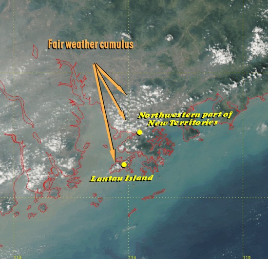 |
This is a high-resolution image captured by an Earth Observing System (EOS) satellite on 28 October 2004. The weather was fine in Hong Kong on that day. Most part of the territory was cleared of clouds. Some clouds, known as fair weather cumulus, were found above Lantau Island and the northwestern part of the New Territories. This type of clouds, looking like cotton balls, does not cause rain. |
|
Image time - 1:14 p.m., 28 October 2004 The true colour image was captured by EOS AQUA satellite. This was generated by combining the satellite data from channels 1, 3 and 4. The image likens the view as seen by naked eyes from space. To know more about weather satellites, please refer to the Notes. | |
| Miscellaneous | |
| Cold Front | 7 March 2003 |
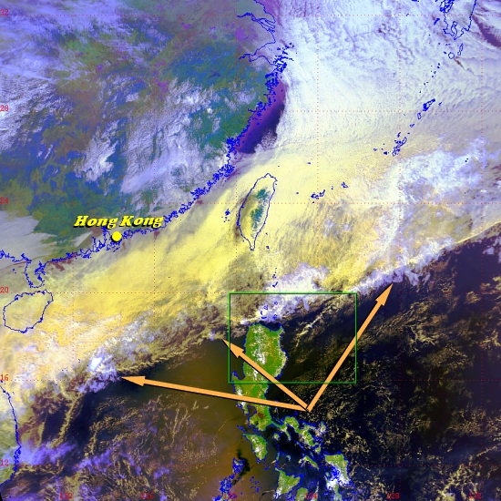 |
The satellite image in Fig.1 shows the sharp edge of an extensive area of clouds that extends from the northern part of the South China Sea to the northwestern part of the Pacific Ocean. This sharp edge (as indicated by the arrows) marked the location of a southward-moving cold front. At some distance behind the cold front, dry air already reached southern China, leaving Hong Kong and some parts of Guangdong relatively cloud-free. |
|
Fig. 1 Image time - 1:36 p.m., 7 March 2003. The satellite image, which was captured by NOAA-16, was specially processed using channels 1, 2 and 4, with assignment of colours to bring out features of special interest. Major features appearing on the image include thick clouds (white), low clouds (yellow) and high clouds (purplish blue). To know more about weather satellites, please refer to the Notes. | |
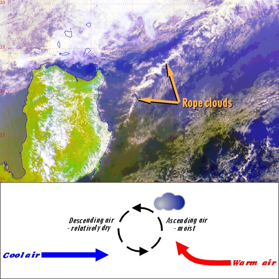 |
Near the cold front there were thin 'rope' clouds. A rope cloud represents a roll-like circulation about a horizontal axis, with clouds forming in the ascending part of the roll. Can you spot other rope clouds in Fig. 1? |
| Fig. 2 (Top) 'Rope' clouds. (Bottom) Formation mechanism of 'rope' cloud. | |
|
Miscellaneous | |
|
15 January 2003 | |
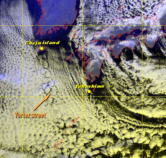 |
At the time the image was taken, wintry north to northwesterly winds prevailed over the area. A vortex street can often be seen downwind of Cheju Island, Korea. The vortices, known as von Karman vortices, appear when the air flow is disturbed by an object standing in the way. The alternating vortices rotate in opposite directions, i.e. clockwise and counter-clockwise. Can you spot another vortex street in the image? |
|
Image time - 8:32 a.m., 15 January 2003 The satellite image, which was captured by GMS-5, was specially processed using VIS and IR1 channels, with assignment of colours to bring out features of special interest. Clouds are in white to pale yellow colours. To know more about weather satellites, please refer to the Notes. | |
|
Miscellaneous | |
|
15 August 2002 | |
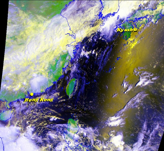 |
FY-1D is a polar-orbiting satellite launched by China on 15 May 2002. This satellite image is the first FY-1D image received by the Hong Kong Observatory. The yellowish glare to the South of Kyushu is sunlight reflected by the sea surface. |
|
Image time - 8:41 a.m., 15 August 2002 The satellite image, which was captured by FY-1D, was specially processed using channels 1, 2 and 4, with assignment of colours to bring out features of special interest. Major features appearing on the image include reflection of sunlight (yellow), deep clouds (white), low clouds (pale yellow), high clouds (blue), vegetation (green) and sea (dark). To know more about weather satellites, please refer to the Notes. | |
| Miscellaneous | |
| Sun Glint | 18 June 2002 |
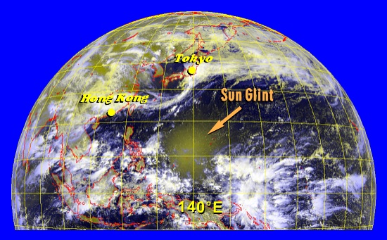 |
The middle of the image shows a bright but diffuse patch over the tropical Pacific, with a horizontal extent of more than 1500 km across. This is called sun glint, a result of direct reflection of sunlight over a relatively calm sea. At the time the image was taken the Sun was overhead the satellite at 140oE. Weatherwise, a ridge of high pressure covered that area, bringing fine weather and light winds, hence the calm sea. |
|
Image time - 10:32 a.m., 18 June 2002 The satellite image, which was captured by GMS-5, was specially processed using VIS and IR1 channels, with assignment of colours to bring out features of special interest. Major features appearing on the image include deep clouds (white), low clouds (grayish yellow), land or sun glint (yellowish green) and sea (dark). To know more about weather satellites, please refer to the Notes. | |
| Miscellaneous | |
| Fohn Effect | 8 January 2002 |
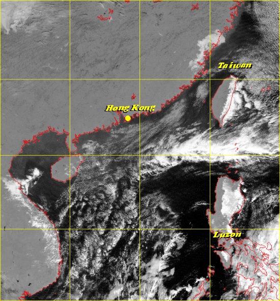 |
When air travels up the windward slope of a mountain, it condenses to form clouds if it is sufficiently moist and the surrounding is sufficiently cool. On its way down, the air, deprived of moisture, becomes dry and warm, bringing fine weather to the lee side of the mountain. The phenomenon is called Fohn effect. The satellite picture here shows an example of Fohn effect over Luzon, the Philippines. At the time, winds were blowing generally from the east, hence the appearance of clouds over the eastern (i.e. windward) side of Luzon. Note that the western (i.e. lee) side of Luzon is practically cloud-free. Can you identify the Fohn effect in another area of the picture? |
|
Image time - 10:32 a.m., 8 January 2002 The visible satellite image was captured by GMS-5. To know more about weather satellites, please refer to the Notes. | |
|
Miscellaneous | |
|
22 October 2001 | |
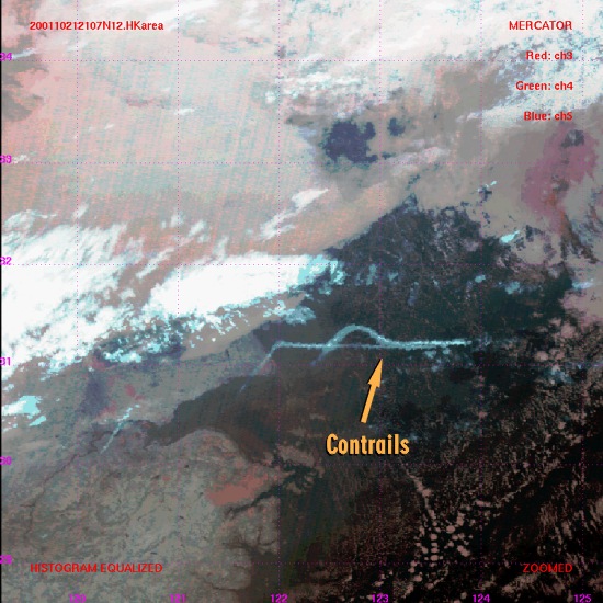 |
Condensation trails (contrails) are formed high in the sky where water vapour from aircraft exhaust condenses in the surrounding cold air, producing water droplets and/or ice crystals. They appear as narrow, sometimes rather straight, streaks on satellite cloud images. |
|
Image time - 5:07 a.m., 22 Octobert 2001 The satellite image, which was captured by NOAA-12, was specially processed using channels 3B, 4 and 5, with assignment of colours to bring out features of special interest. Major features appearing on the image include contrails (light blue), deep clouds (white), high clouds (light blue) and fog/mist/low clouds (red - smooth in texture). To know more about weather satellites, please refer to the Notes. | |
|
Miscellaneous | |
|
15 October 2001 | |
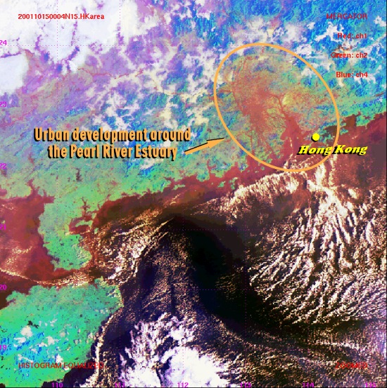 |
The circled area on the satellite image indicates rather extensive urbanization (reddish in colour). It contrasts sharply with the adjacent vegetated areas (green). |
|
Image time - 8:04 a.m., 15 October 2001 The satellite image, which was captured by NOAA-15, was specially processed using channels 1, 2 and 4, with assignment of colours to bring out features of special interest. Major features appearing on the image include developed area (red to yellow), vegetation (green), high ground (blue) and clouds (white). To know more about weather satellites, please refer to the Notes. | |