Let's talk about rainstorm warning (Part 1): Origin
3 April 2018
Origin of rainstorm warningOn the morning of 8 May 1992, the Observatory recorded some 110 millimetres of rainfall in an hour that set the highest hourly rainfall record at that time [Note 1]. There were serious flooding and landslips in places on that day while the traffic in various districts was paralysed. Tragically, even some people lost their lives. This rainstorm led to the establishment of the Rainstorm Warning Signal, which aims to reflect objectively the impact of heavy rain on our society. It also aims to caution the public about the major disruption that a rainstorm may bring, so as to enable them to take precautionary measures to avoid loss of life and property.
Time flies. The rainstorm warning system has been implemented for over a quarter-century. During 2013 to 2017, the Observatory had issued the Black Rainstorm Warnings five years in a row. As extreme weather will become more frequent due to global warming, a better understanding of the origin and meaning of the rainstorm warning system will enable us to respond timely under adverse weather.
Considerations of rainstorm warning
Although Hong Kong is small in area, its terrain is complex and the impact of heavy rain, flooding or landslip in different regions is not the same. The rainstorm warning should be operated with due consideration of the overall emergency response. We cannot consider solely the spatial coverage of heavy rain, but also need to take into consideration such risk factors as heavy-rain-induced flooding and landslip as well as the size of the affected population. Currently, data of over 100 rain gauges scattered around Hong Kong is being used by the Observatory to determine whether or not to issue a rainstorm warning signal and, if issued, the level of warning. These rain gauges are not distributed evenly across the territory. There are a number of factors being considered. The rain gauges are denser in areas of higher risk of flood and landslip and higher population density (Figure 1). If heavy rain falls over areas of denser rain gauges, the number of rain gauges recording high rainfall level will then be higher, and thereby higher chance of issuing rainstorm warning. In the event that the amount of rainfall reaches a certain level that the risk of landslip in Hong Kong becomes high and numerous landslips are likely, the Observatory will also issue a landslip warning [Note 2].
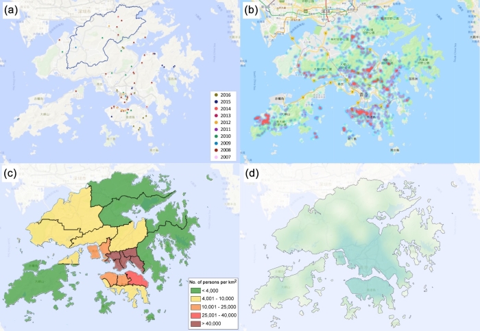
Figure 1
(a)Distribution of severe flooding cases from 2007 to 2016 (based on data provided by the Drainage Services Department). The blue line indicates the area applicable to the Special Announcement on Flooding in the northern New Territories;
(b)Distribution of landslip locations from 2007 to 2016. The redder the colour, the higher the number of landslip cases in the area. Red colour represents over 10 landslip cases per square kilometre in general (based on data provided by the Civil Engineering and Development Department);
(c)Population density in 2016 according to District Council districts (based on data provided by the Census and Statistics Department);
(d)Density distribution of reference rain gauges. Darker colour indicates a higher density of rain gauges, while lighter colour represents a lower density. Dark green means a density of over 3 rain gauges in 10 square kilometres in general.
Taking the heavy rain episode on the night of 8 June 2014 as an example (Figure 2), the Observatory issued the Amber and the Red Rainstorm Warning Signals in succession that night. While the rain was heavier on Hong Kong Island, Kowloon and Tseung Kwan O, there was generally not much rain over other parts of the New Territories. No rain was even recorded in some places. This episode of rain happened to fall over the areas of higher risk of impact brought by weather and of higher population density. The Observatory eventually issued the Red Rainstorm Warning and serious flooding affected many roads on Hong Kong Island and in Kowloon.
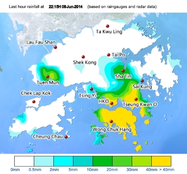
Figure 2 Rainfall distribution at 10:15 p.m. on 8 June 2014.
As for another heavy rain episode that affected mainly the northern part of the New Territories on the morning of 24 July 2015 (Figure 3), the Observatory did not issue a rainstorm warning, but issued the Special Announcement on Flooding in the northern New Territories that was tailored for that area. The rainfall distribution map shows that the hourly rainfall in most parts of Hong Kong did not reach 30 millimetres, except for the northern part of the New Territories. Hence, the rainstorm warning was not issued. To conclude, the overall impact of this heavy rain episode on Hong Kong was relatively low.
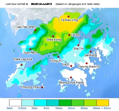
Figure 3 Rainfall distribution at 8:45 a.m. on 24 July 2015.
Localised heavy rain
Given that rainstorm warning is a territory-wide warning system directly affecting all people going to work and to school rather than a system catering for localised situation, the Observatory launched the Announcement on Localised Heavy Rain service in the summer of 2016. When rain is particularly heavy in individual districts of Hong Kong, and yet to reach the criteria of the Red or Black Rainstorm Warning Signal, the Observatory will indicate the affected districts and the recorded rainfall in the Announcement on Localised Heavy Rain to remind the public to take precautions against the risk of flooding. Since flooding may lag behind the rain, the risk will not abate immediately even when the rain starts to ease off.
"Flooding can happen even it is just Amber"
It is worth noting that when the Amber Rainstorm Warning is in force, flooding may occur in some low-lying or poorly drained areas, and rivers may also overflow. Therefore, the impact of the Amber Rainstorm Warning should never be underestimated. The Red and the Black Rainstorm Warnings indicate even worse situations. In particular, the Black Rainstorm Warning indicates an adverse situation with a high chance of serious flooding, river overflow, landslip, and traffic paralysis. The public should stay in safe places to avoid any danger.
Threshold of warning
Like the tropical cyclone warning signal, the rainstorm warning signal is a territory-wide warning system. However, the uncertainty of rainstorm is much greater than that of tropical cyclone. Heavy rain can develop in a short time, and the intensity of rain and the movement of rain band have some degrees of randomness. It is still a challenge to precisely predict them with the current science and technology.
One may wonder, what about lowering the threshold for the rainstorm warning, for example, issuing rainstorm warning as long as heavy rain occurs in certain individual areas (even though rain is not heavy in all other areas), or lowering the rainfall criteria for all levels of rainstorm warning (such as lowering the criterion of the Amber Rainstorm Warning from 30 millimetres per hour to 20 millimetres per hour, or even less)? If that is the case, the following situation may occur: the number of rainstorm warnings issued will increase substantially, yet the overall impact of rainfall on Hong Kong may not be serious every time. Over time, the public may feel accustomed to the warning, or even feel annoyed, eventually lowering their alertness to the rainstorm warning or even becoming negligent. When a destructive rainstorm comes then, the public may be caught off guard, causing unwanted loss of property or even human life.
Safeguarding public safety through science
The Observatory has always been serving the public with science and safeguarding public safety as its primary mandate. Through various weather warnings and information, the Observatory strives to remind the general public of the risks they may face. The Observatory also constantly performs reviews and seeks improvement, such as examining the distribution of the reference rain gauges of the rainstorm warning system, and providing more detailed weather information at the location of users through the MyObservatory mobile application. We advise members of the public not only to pay attention to the Observatory's information, but also assess the risks they may face based on their own experience and current situation. When necessary, they should stay away from dangerous places and seek assistance from emergency departments immediately.
Next time, we will talk about topics on rainstorm warning signal that you may be interested, such as the feasibility of implementing a district-level rainstorm warning, or the possibility of providing alert a couple of hours in advance before the rainstorm occurs, similar to that for tropical cyclone warning.
L.S. LeeM.C. Chow
Note 1: New records were made subsequently in 2006 and 2008.
Note 2: The rainstorm warning aims to alert the public to the impact brought by rainstorms, whereas the landslip warning aims to alert the public to potential landslip hazards and is issued by the Observatory in consultation with the Geotechnical Engineering Office.