Capturing Local Ground Motion: The Key Role of Peak Ground Acceleration in Earthquake Monitoring
Capturing Local Ground Motion: The Key Role of Peak Ground Acceleration in Earthquake Monitoring
WONG Cheuk-yiu Lillian and LAM Ching-chi Queenie
June 2025
When it comes to earthquakes, most people will think of places like Japan, Indonesia, and The Philippines. As for Hong Kong, many people may wonder, “Does Hong Kong really experience earthquakes?“ Hong Kong lies within the Eurasian Plate, and is not located at the boundaries of tectonic plates. It is quite far from the active circum-Pacific seismic belt (commonly known as “Pacific Ring of Fire”), with the nearest point being 600 km away. The seismic risk in Hong Kong is indeed much lower than that in those seismically active regions. Studies by the Geotechnical Engineering Office (GEO) of the Civil Engineering and Development Department (CEDD) also indicate that there is no clear evidence of significant recent fault activities in Hong Kong, either onshore or offshore [1].
Yet, this does not mean that Hong Kong is entirely unaffected by earthquakes. Since 1905, the Hong Kong Observatory (HKO) has recorded over 200 locally felt earth tremors, averaging about two per year. These tremors, which produce subtle but perceptible shaking, mostly originate from neighbouring regions, while some distant but strong earthquakes can also induce local shaking. The most severe event in history was the 1918 earthquake near Shantou, which occurred about 300 kilometres from Hong Kong and caused minor damage to a few buildings in Hong Kong – the only event on record that resulted in damage [2].
Given Hong Kong’s dense population, it is vital to disseminate earthquake messages rapidly and effectively following a locally felt earth tremor to prevent public panic. As the official earthquake monitoring authority in Hong Kong, HKO needs to swiftly determine local ground motion and assess the corresponding impact to Hong Kong, with Peak Ground Acceleration (PGA) serving as a key metric in this process.
Relationship Between Earthquake Intensity and Peak Ground Acceleration
In contrast to the HKO’s Strong Earthquake Report, the Locally Felt Earth Tremor Report provides additional information, notably earthquake intensity that reflects local impact. Unlike magnitude, which represents the energy released at the hypocentre with each type of magnitude denoted by a single value with the energy approximately increasing by 32 times for each incremental magnitude level and leading to about a 1000-fold difference in energy between two magnitude levels, intensity describes the effect or damage caused by the shaking at different locations. Intensity is influenced by factors such as distance from the epicentre, geological conditions and the direction of earthquake rupture (Figure 1) [3]. Hong Kong adopts the Modified Mercalli Scale (MMS) to describe earthquake intensity (Table 1).
Globally, PGA is a critical objective metric for assessing intensity, alongside post-earthquake field surveys in the affected regions after an earthquake occurs. PGA indicates the maximum acceleration experienced by a small object on the ground, or the highest rate of change of speed that the ground undergoes as seismic waves pass through. It is expressed in units of gravitational acceleration (g where 1 g ≈ 9.8 m/s²) or “Gal” (cm/s², 1 Gal ≈ 0.001 g). By directly quantifying the ground motion near the point of measurement, PGA helps assess the impact of the vibrations on humans, furniture, buildings, geological structures, and etc.
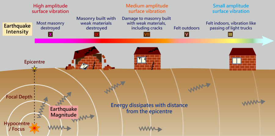
Figure 1 Schematic diagram explaining different seismic parameters.
| MMS | Effects |
|---|---|
| I | Not felt. |
| II | Felt by persons at rest, upper floors, or favorably placed. |
| III | Felt indoors. Hanging objects swing slightly. Vibration like passing of light trucks. |
| IV | Hanging objects swing. Vibration like passing of heavy trucks. Standing motor cars rock. Windows, dishes, doors rattle. |
| V | Felt outdoors; direction estimated. Vast majority of sleepers wakened. Liquids disturbed, some spilled. Small unstable objects displaced or upset. |
| VI | Felt by all. Many frightened and run outdoors. Persons walk unsteadily. Windows, dishes, glassware broken. |
| VII | Difficult to stand. Noticed by drivers of motor cars. Hanging objects quiver. Furniture broken. Masonry buildings made of fragile materials and poor workmanship suffered from cracks and damage. |
| VIII | Steering of motor cars affected. No reinforced brick buildings damaged, and some partially collapsed. |
| IX | General panic. Fragile brick buildings destroyed. |
| X | Most brick buildings and wooden houses with foundations destroyed. Dams, ditches and embarkments severely damaged. Large landslides. |
| XI | Rails bent greatly. Underground pipelines completely out of service. |
| XII | Damage nearly total. Large rock masses displaced. Lines of sight and level distorted. |
Table 1 Hong Kong adopts Modified Mercalli Scale (MMS) to describe earthquake intensity.
How Does the Observatory Monitor Earthquakes?
The HKO operates broadband seismometers at various locations, including Po Shan Road at Mid-Levels on Hong Kong Island and the HKO Headquarters at Tsim Sha Tsui. It exchanges real-time waveform data with several hundreds of seismic stations around the world to monitor earthquakes worldwide. The HKO also operates seismic stations equipped with short-period seismographs distributed across different districts of Hong Kong. These short-period seismographs are designed to detect high-frequency seismic waves, making them effective for monitoring local and regional earthquakes. Together, these stations form the Hong Kong Seismograph Network, and the recorded seismic waves help determine effectively the origin time, epicentre and magnitude of earthquakes occurring in Hong Kong and its nearby regions. Strong motion accelerographs that specifically measure PGA were also installed at some of these stations. As these instruments directly record acceleration (rate of change of direction and magnitude of velocity), and are unaffected by the frequency of seismic waves, they can thus capture ground motion induced by intense earthquakes beyond the range of conventional seismographs. In addition, HKO also collaborates with the Guangdong Earthquake Agency (GEA) to set up a new network of earthquake intensity meters that measure PGA too. They have looser site requirements and lower price, but are less sensitive to weaker signals. They are not intended for detection of micro-earthquakes. This intensity meter network was set up in 2024. It undergoes system adjustment and testing as well as data manipulation and processing in 2025. It will be integrated into the network to enhance the coverage of the earthquake monitoring network in the region once testing is completed.
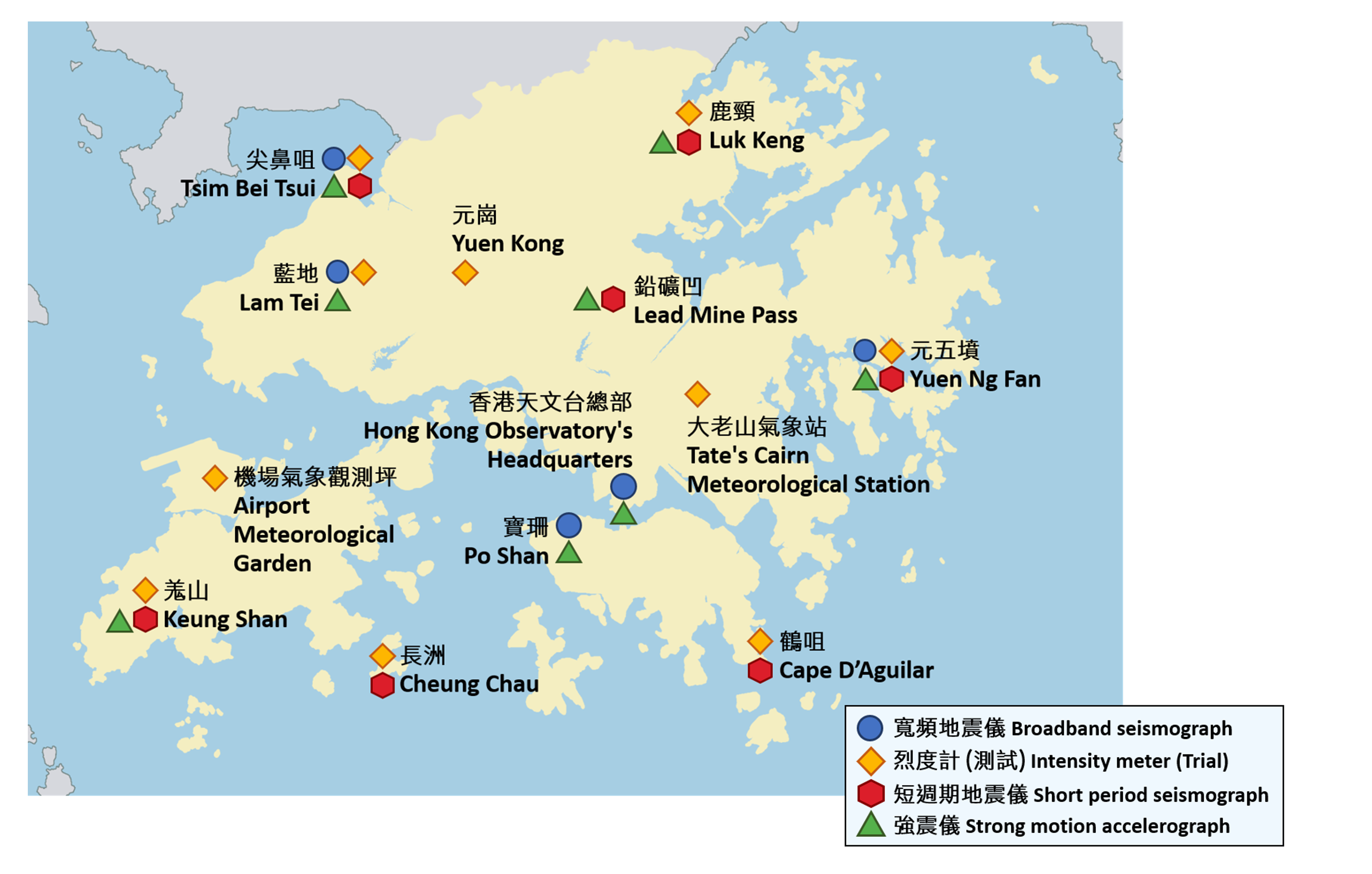
Figure 2 Hong Kong Seismograph Network (Updated in June 2025).
Applications of PGA at HKO
When a locally felt earth tremor occurs in Hong Kong, HKO determines the earthquake intensity by considering both public reports submitted via online form or telephone and PGA data. To better reflect human observations or sensations, HKO correlates the earthquake intensity determined from filtered public reports with PGA values measured by instruments using a sufficient number of past locally felt earth tremors to establish an objective way to determine a local earthquake intensity scale based on instrument readings.
On 14 March 2022, an earthquake with magnitude 4.1 occurred over waters of Huizhou, Guangdong. HKO received over 10,000 reports of shaking, the highest on record since 1979, when HKO set up a short-period seismograph network and got hold of detailed public reports of locally felt earth tremor. The strong motion accelerograph network of HKO detected signals about one minute after the earthquake occurred. The Yuen Ng Fan station in eastern Hong Kong recorded the highest PGA of 20.7 Gal, while stations in other districts recorded PGAs below 6 Gal (Figure 3). Based on these observations and the reports received, HKO rated the local intensity as IV (Four) on the MMS.
PGA can also help verify the occurrence of microearthquakes. Microearthquakes which are minor earthquakes with magnitude 2 or below [4] such as the event of magnitude 2.0 over Lantau Island on 11 March 2024. They often go unnoticed unless they are shallow enough and occur near areas of human activity. As the seismic waves generated by a microearthquake propagate, their energy gradually attenuates with distance from the epicentre. Coupled with their small initial amplitudes, they can only be captured by a limited number of stations. Automated analyses may thus misjudge microearthquakes. For instance, if unrelated waves detected by distant stations are included in the calculations, it will cause errors in epicentre location and overestimation of magnitude. In this case, it necessitates manual analyses. Here, PGA data provide critical objective evidence during the “fact-check” process. It could even alert HKO of potential locally felt earth tremors before reception of public reports.
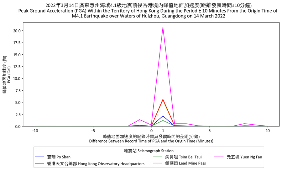
Figure 3 The PGA measured by the five strong motion accelerographs of HKO around the occurrence of the earthquake with magnitude 4.1 at 2:29 a.m. on 14 March 2022 over waters of Huizhou, Guangdong.
Future Development of HKO’s Seismic Network
The HKO is dedicated to continuously enhancing its earthquake monitoring capabilities by setting up additional seismograph stations in Hong Kong and its neighbouring areas. The 2025 plan includes additional stations in Lam Tei, Tuen Mun, and Huangmao Zhou south of the Pearl River Delta, so as to improve the coverage of the seismograph network. In collaboration with GEA, the HKO will further strengthen the regional earthquake monitoring network, aiming to boost earthquake monitoring capabilities in the Guangdong-Hong Kong-Macao Greater Bay Area and further enhance earthquake information services.
References:
[1] CEDD: GEO Information Notes 21/2022.
[2] HKO’s Blog: A 'shocking' Lunar New Year one hundred years ago.
[3] HKO Educational Resources: How to Interpret Seismic Parameters?
[4] Bormann, P., Aki, K., Lee, W. H. K., Schweitzer, J. (2013): Glossary. - In: Bormann, P. (Ed.), New Manual of Seismological Observatory Practice 2 (NMSOP 2), Potsdam : Deutsches GeoForschungsZentrum GFZ, 1-200.