Dropsonde Missions – Data Quest in the Heart of Typhoon
Dropsonde Missions – Data Quest in the Heart of Typhoon
CHONG Man-lok
February 2026
Tropical cyclones typically develop over open seas far from land, where relevant in-situ meteorological data, such as those from island weather stations and buoys, are often sparse. The assessment of a tropical cyclone’s position, intensity and structure relies heavily on remote-sensing observations, primarily from satellites and radars. Although these observations offer wide coverage and high density, they cannot override the importance of in-situ measurements within the storms.
In 2009, the Observatory commenced flight data collection missions with the Government Flying Service (GFS), using onboard meteorological data measuring systems to collect data during flights. The cooperation extended to reconnaissance flights to capture weather data near tropical cyclones over the South China Sea in 2011 [1]. During a reconnaissance mission for Tropical Cyclone Megi in September 2016, the Observatory used a dropsonde for the first time to carry out in-situ meteorological measurements. Since then, dropsonde missions have been conducted for many typhoons that posed severe threat to Hong Kong, such as Mangkhut, Saola, Wipha and Ragasa.
Dropsonde missions are usually conducted at altitudes of 10 kilometres or more above sea level, with the dropsonde released through a launcher tube at the rear of the aircraft. A dropsonde contains a Global Positioning System (GPS) antenna and receiver, meteorological data sensors, and other components (Figure 1) to collect meteorological data at different altitudes near tropical cyclones, including wind direction, wind speed, temperature, humidity and atmospheric pressure. The winds aloft are calculated by tracking the movement of the dropsonde with the ambient airflow through GPS. The data are transmitted in real time to the aircraft via a radio transmitter. In addition, the parachute attached to the dropsonde slows its descent, ensuring more ample and stable measurements. Typically, it takes more than 10 minutes for the dropsonde to descend from release to landing on the sea surface.
Data at different altitudes within a tropical cyclones help analyze their three-dimensional structure and wind direction, wind speed and pressure measured near sea level are particularly important for determining the storm’s position, intensity and wind field. During the reconnaissance mission of Super Typhon Ragasa in 2025, a dropsonde about 120 kilometers from the storm centre recorded hurricane force near-surface winds on the morning of 23 September, indicating that Ragasa had a very broad hurricane force wind area (Figure 2). The data played a crucial role in the Observatory's subsequent decision to issue the Hurricane Signal No. 10. Dropsonde data can also be assimilated into numerical weather prediction (NWP) models, and studies have shown that the data can improve the accuracy of tropical cyclone intensity and track forecasts [2].
The dropsonde data are disseminated to the World Meteorological Organization’s Global Telecommunication System, for use by meteorological centres and NWP centres worldwide. Data are also transmitted to meteorological agencies and research institutes in the Mainland via dedicated data links, aiming to provide strong support for typhoon forecasting and disaster prevention. Since early 2024, the Observatory has actively collaborated with the China Meteorological Administration (CMA), the Shanghai Typhoon Institute, and the Asia-Pacific Typhoon Collaborative Research Center to conduct joint aircraft observations, expanding the observational coverage and increasing the volume of observation data.
Tropical cyclone reconnaissance missions bear certain risks. While the cyclonic circulation and spiral rainbands of tropical cyclones are primarily located in the middle and lower troposphere, aircraft may still encounter turbulence, hail and icing at altitudes of 10 kilometres or above. The professional operation by GFS personnel under extreme weather conditions is indispensable for the success in every aircraft reconnaissance mission. The valuable in-situ data collected provide a solid basis for scientific decision-making, as well as disaster prevention and reduction.
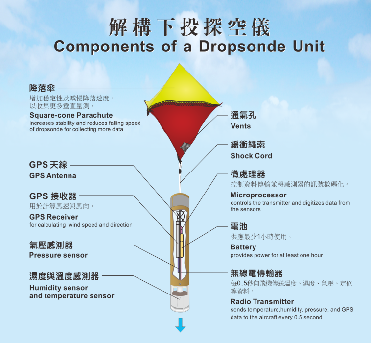
Figure 1 Schematic diagram of a dropsonde unit.
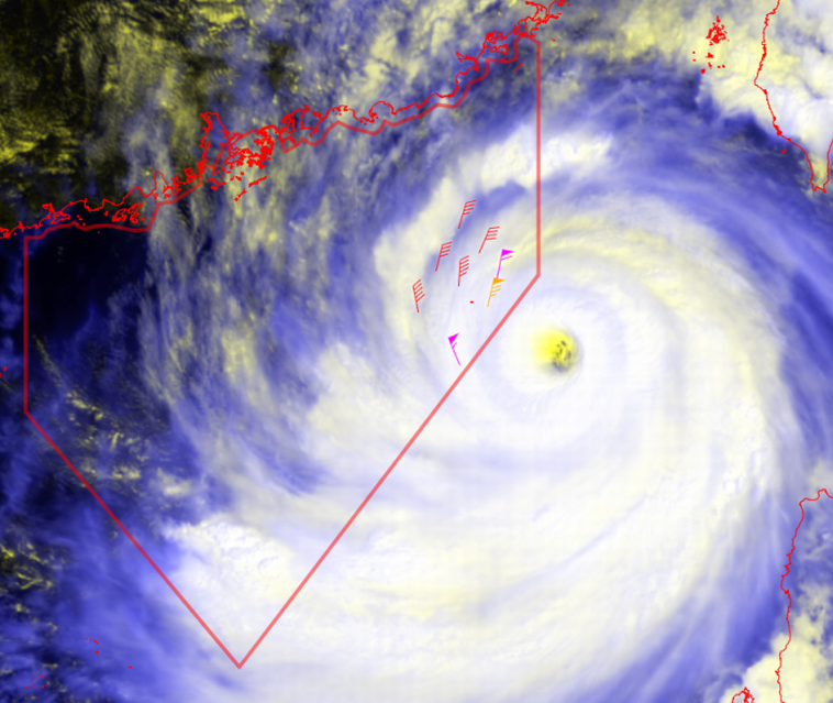
Figure 2 Near-surface winds collected around Super Typhoon Ragasa on the morning of 23 September 2025 by dropsonde mission of HKO.
References:
[1] Hong Kong Observatory: Aircraft Meteorological Observation for Tropical Cyclones.
[2] Ditchek, S. D., J. A. Sippel, G. J. Alaka, S. B. Goldenberg, and L. Cucurull, 2023: A Systematic Assessment of the Overall Dropsonde Impact during the 2017–20 Hurricane Seasons Using the Basin-Scale HWRF. Wea. Forecasting, 38, 789–816.