Overview of Tropical Cyclone in October 2024
|
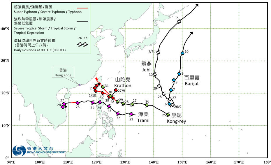
Five tropical cyclones occurred over the western North Pacific and the South China Sea in October 2024. Among them, Trami necessitated the issuance of the tropical cyclone warning signals by the Observatory. Jebi formed as a tropical depression over the western North Pacific about 1 080 km south-southeast of Iwo Jima on the morning of 26 September and moved generally north-northwestwards towards the seas south of Iwo Jima. It intensified into a tropical storm on the afternoon of the next day. Jebi moved across the vicinity of Iwo Jima and gradually turned to move north-northeastwards towards the seas east of Japan on 29 – 30 September. It intensified into a severe tropical storm and gradually turned to track northeastwards, when moving across the seas east of Honshu, Japan on 1 October. Jebi attained its peak intensity with an estimated maximum sustained wind of 105 km/h near its centre that night. It finally evolved into an extratropical cyclone on the night of 2 October over the seas east of Hokkaido. Krathon formed as a tropical depression over the western North Pacific about 600 km south of Okinawa on the morning of 27 September and moved southwestwards at first. It lingered over the seas east of the Luzon Strait and intensified gradually the next day. Krathon began to pick up speed to track west-northwestwards, and rapidly intensified into a severe typhoon from a severe tropical storm on 29 September. It further intensified into a super typhoon in the small hours of 30 September, and then moved across the Luzon Strait. Krathon attained its peak intensity with an estimated maximum sustained wind of 210 km/h near its centre in the small hours of 1 October. It gradually turned to move northeastwards, slowly approaching the southwestern part of Taiwan in the following two days. Krathon made landfall over Gaoxiong on the afternoon of 3 October, and then weakened rapidly while lingering over the southern part of Taiwan. It finally degenerated into an area of low pressure in the small hours of the next day. According to press reports, Krathon brought torrential rain to the northern part of the Philippines. A record-breaking 24-hour rainfall of 727.8 millimetres was reported in Batanes Islands. In the Philippines, there were five deaths, one missing, 12 injuries, and over 380 000 people affected. More than 2 800 houses were damaged. Economic loss exceeded PHP 1.5 billion. Krathon and its remnant also brought torrential rain and squalls to Taiwan. A record-breaking daily rainfall of 408 millimetres was reported in Keelung on 3 October. In Taiwan, days of torrential rain and squalls caused at least four deaths, one missing and 719 injuries. Water and electricity supply to more than 600 000 and 430 000 households were disrupted respectively. Economic loss exceeded USD 19 million. Marine, land and air traffic were also affected, with over 460 flights cancelled. Barijat formed as a tropical depression over the western North Pacific about 1 120 km south-southeast of Iwo Jima in the small hours of 6 October. It moved generally northwards or north-northeastwards across the seas east of Iwo Jima in the following three days. Barijat intensified into a tropical storm and attained its peak intensity with an estimated maximum sustained wind of 65 km/h near its centre on the night of 9 October. It finally evolved into an extratropical cyclone over the western North Pacific to the east of Japan in the small hours of 11 October. Trami formed as a tropical depression over the western North Pacific about 1 370 km east of Manila in the small hours of 21 October, moved westwards towards the seas east of the Philippines, and intensified gradually. It intensified into a tropical storm in the small hours of the next day and then turned to move west-northwestwards or northwestwards towards Luzon. Trami moved across Luzon on 24 October and entered the central part of the South China Sea that afternoon. Trami intensified into a typhoon on the morning of 26 October and attained its peak intensity with an estimated maximum sustained wind of 120 km/h near its centre. Under the influence of the relatively high vertical wind shear over the central part of the South China Sea, Trami weakened gradually afterwards. It turned to track south-southwestwards the next morning and made landfall over the central part of Vietnam around noon. With a relatively weak steering flow, Trami then lingered over the coastal areas and finally degenerated into an area of low pressure on the morning of 28 October. According to press reports, Trami brought torrential rain and squalls to the Philippines, leading to flooding and landslides, resulting in many casualties and significant economic loss. Under the influence of Trami and its remnant, torrential rain occurred in Hainan on 26 – 31 October, with a maximum cumulative rainfall of 1243.1 millimetres recorded in Qionghai during the period. Flooding and landslides triggered by torrential rain led to ten deaths, more than 550 000 people affected and an economic loss of about RMB 230 million. Trami also brought very heavy rain to Vietnam, causing at least three deaths, one missing and more than 290 houses damaged. For detailed information of Trami including its impact to Hong Kong, please refer to the Tropical Cyclone Report of Trami. Kong-rey formed as a tropical depression over the western North Pacific about 870 km east-northeast of Yap on the morning of 25 October. In the following three days, it tracked generally westwards or west-northwestwards across the western North Pacific to the east of Luzon, and gradually intensified into a severe tropical storm. Kong-rey turned to move northwestwards towards the southeastern part of Taiwan on 29 October, and then rapidly intensified into a super typhoon, attaining its peak intensity with an estimated maximum sustained wind of 205 km/h near its centre the next morning. Kong-rey weakened rapidly while moving across Taiwan on the afternoon of 31 October, and entered the Taiwan Strait that night. |
Provisional Tropical Cyclone Tracks in October 2024