Overview of Tropical Cyclone in July 2025
|
Eight tropical cyclones occurred over the western North Pacific and the South China Sea in July 2025. Among them, Danas (2504) and Wipha (2506) necessitated the issuance of the tropical cyclone warning signal by the Observatory. Mun (2503) formed as a tropical depression over the western North Pacific about 770 km east-southeast of Iwo Jima on the afternoon of 1 July, and moved northwestwards or north-northwestwards. It intensified into a tropical storm in the small hours of 3 July over the seas east of Iwo Jima, and turned to move northeastwards or east-northeastwards the next day. Mun attained its peak intensity with an estimated maximum sustained wind of 85 km/h near its centre in the small hours of 5 July. It turned to move generally northwards on 6 July and finally degenerated into an area of low pressure over the western North Pacific to the east of Japan on the afternoon of 8 July. Danas (2504) formed as a tropical depression over the northeastern part of the South China Sea about 260 km east-southeast of Dongsha on the morning of 4 July and moved northwestwards slowly. It intensified into a tropical storm in the small hours of the next day. Danas made the first sharp turn on 5 July, taking a northeasterly track. Danas started to pick up speed on 6 July and rapidly intensified into a severe typhoon just before making landfall over Chiayi of Taiwan that night, attaining its peak intensity with an estimated maximum sustained wind of 155 km/h near its centre. Danas weakened when it moved across Taiwan. It then entered the East China Sea and continued to move northeastwards during the day on 7 July. Danas made the second sharp turn over the East China Sea on 8 July, moving west-southwestwards towards Zhejiang. It made landfall again over Wenzhou of Zhejiang that night. It then moved inland via a southwesterly track and weakened. Danas finally degenerated into an area of low pressure over Fujian on the night of 9 July. According to press reports, Danas, together with the southwest monsoon, brought heavy rain to the northern part of the Philippines, causing one death and affecting approximately 100 000 people. Economic loss exceeded PHP 12.4 million. Danas brought torrential rain and squalls to Taiwan during its passage from the night of 6 July to the next morning. Danas and the active southwest monsoon continued to bring torrential rain to Taiwan in the following three days. A maximum accumulated rainfall of over 1 100 millimetres was recorded in Pingtung during this period. Torrential rain and squalls resulted in two deaths and at least 700 injuries. Water and electricity supplies to more than 70 000 and one million households were disrupted respectively. Over 18 000 houses were damaged. Economic loss exceeded USD 51 million. Affected by Danas, its remnant and the active southwest monsoon, there was persistent heavy rain over Zhejiang, Fujian and Guangdong on 8 – 12 July. For detailed information of Danas including its impact to Hong Kong, please refer to the Tropical Cyclone Report of Danas. Nari (2505) formed as a tropical depression over the western North Pacific about 170 km south-southeast of Iwo Jima on the night of 10 July, and lingered over the vicinity of Iwo Jima in the next two days. Nari intensified into a tropical storm in the small hours of 13 July, and then picked up speed to track northwards towards the seas east of Honshu, Japan. It attained its peak intensity with an estimated maximum sustained wind of 85 km/h near its centre that night. Nari moved across Hokkaido in the small hours of 15 July, and finally evolved into an extratropical cyclone over the seas north of Hokkaido that morning. A tropical depression formed over the East China Sea about 250 km east-southeast of Shanghai in the small hours of 12 July, and lingered in the region. The tropical depression attained its peak intensity with an estimated maximum sustained wind of 55 km/h near its centre that morning. It picked up speed to track eastwards or east-northeastwards across the East China Sea the next day, and finally degenerated into an area of low pressure over Kyushu, Japan on the morning of 14 July. According to press reports, Nari and the remnant of the tropical depression brought heavy rain to many places in Japan, causing two injuries and 24 damaged houses. Wipha (2506) formed as a tropical depression over the western North Pacific about 950 km east of Manila on the night of 16 July. It tracked northwestwards towards the Luzon Strait and intensified gradually into a tropical storm in the following two days. Wipha turned to move west-northwestwards across the Luzon Strait on the night of 18 July. It entered the northern part of the South China Sea on 19 July, edging closer to the coast of Guangdong and intensifying rapidly. It intensified into a typhoon that night and attained its peak intensity with an estimated maximum sustained wind of 140 km/h near its centre during its approach to Hong Kong on the morning of 20 July. It moved westwards across the coastal areas of western Guangdong, made landfall near Yangjiang of Guangdong and weakened gradually later that day. Wipha adopted a west-southwesterly track across Beibu Wan and the northern part of Vietnam and weakened progressively into a tropical depression in the following two days. Wipha finally degenerated into an area of low pressure over Lao PDR on the morning of 23 July. According to press reports, Wipha, together with the southwest monsoon, brought torrential rain and squalls to the Philippines, causing six deaths, five injuries and six missing. More than 1.26 million people were affected and more than 1 500 houses were damaged, with direct economic loss exceeding PHP 460 million. Under the influence of the outer rainbands of Wipha, there was torrential rain over the eastern part of Taiwan on 18 – 20 July, with accumulated rainfall reaching 620 millimetres in Taitung. Wipha also caused damage to infrastructure and aquaculture in Guangdong, Guangxi and Hainan, resulting in direct economic losses estimated at about RMB 1.91 billion. There were five injuries and 163 incident reports in Macau. 160 flights were cancelled at the Macau International Airport. Besides, Wipha also brought torrential rain to the northern part of Vietnam. There were flooding and landslides in Thanh Hoa, submerging roads and homes. For detailed information of Wipha including its impact to Hong Kong, please refer to the Tropical Cyclone Report of Wipha. Francisco (2507) formed as a tropical depression over the western North Pacific about 1 140 km south-southeast of Okinawa on the morning of 22 July, and moved northwestwards or north-northwestwards towards the vicinity of the Ryukyu Islands. It intensified into a tropical storm on the morning of 23 July and attained its peak intensity with an estimated maximum sustained wind of 75 km/h near its centre that night. Francisco turned to move generally westwards towards Fujian on the night of 24 July and then progressively weakened into an area of low pressure in the following two days. Co-May (2508) formed as a tropical depression over the Luzon Strait about 470 km north of Manila on the morning of 23 July. Under the Influence of Francisco over the vicinity of the Ryukyu Islands, Co-May made an anti-clockwise loop over the seas west of Luzon and the coastal areas of western Luzon in the following two days. It intensified into a severe tropical storm on the morning of 24 July and attained its peak intensity that night, with an estimated maximum sustained wind of 110 km/h near its centre. It turned to move generally north-northeastwards across the Luzon Strait and the seas east of Taiwan on 25 July and weakened into a tropical depression the next day. Co-May lingered over the vicinity of the Ryukyu Islands on 27 July. It intensified into a tropical storm again and gradually turned to move northwestwards towards the vicinity of the Yangtze River Estuary in the following two days. Co-May made successive landfalls over Zhejiang and Shanghai on 30 July. It moved inland and gradually weakened the next day. Krosa (2509) formed as a tropical depression over the western North Pacific about 180 km west-northwest of Guam on the morning of 24 July. It moved northwards or north-northeastwards, and intensified gradually in the following three days. Krosa intensified into a typhoon on the morning of 27 July and attained its peak intensity over the seas east of Iwo Jima in the small hours of the next day, with an estimated maximum sustained wind of 140 km/h. It weakened into a severe tropical storm on 29 July, and moved slowly towards the seas south of Honshu, Japan in the following two days. |
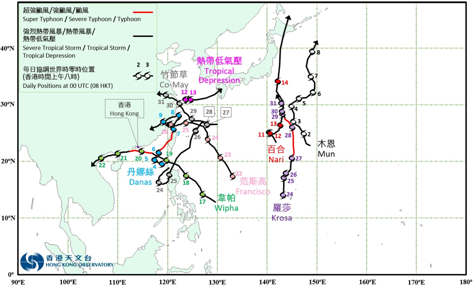
Provisional Tropical Cyclone Tracks in July 2025