The Year's Weather – 2020
Friday, 8th January 2021
Globally, 2020 is on track to be one of the three warmest years on record according to the World Meteorological Organization's preliminary assessment. Over the Arctic, the sea-ice extents for July and October 2020 were the lowest on record and the annual minimum in September was also the second lowest. In 2020, various extreme weather events continued to wreak havoc in different parts of the world, including heatwaves in the Australia, Caribbean region, Mexico, South America, western Europe, eastern Mediterranean, Japan, and Siberia; extreme cold events in North America and the southern part of South America; severe drought in the interior of South America, north-central Europe and parts of the southern Africa; extreme rainfall triggered severe flooding in large parts of Africa, South Asia, China, Korean Peninsula, Viet Nam and parts of western Japan; and severe damages and heavy casualties brought by tropical cyclones in the United States, Caribbean region, Central America, India, Bangladesh, Fiji, Vanuatu, the Philippines, Korean Peninsula, western Japan and Viet Nam. Exacerbating by widespread drought and high temperature weather, destructive wildfires ravaged California and Colorado of the United States, northern Siberia, eastern Australia, and western Brazil.
A weak El Niño event was established in April 2020. However, sea surface temperatures of the central and eastern equatorial Pacific dropped rapidly afterwards, returning to normal in May. The cooling trend continued into the second half of the year. Sea surface temperatures of the central and eastern equatorial Pacific became below normal in September and remained colder than normal till the end of the year, indicating the development of a La Niña event.
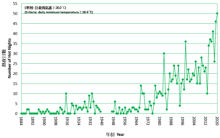
In Hong Kong, with eleven out of the twelve months warmer than usual, 2020 was the second warmest year since records began in 1884 with an annual mean temperature of 24.4 degrees, 1.1 degrees above the 1981-2010 normal[1]. The annual mean maximum temperature of 27.2 degrees and annual mean minimum temperature of 22.5 degrees were respectively the highest and second highest on record. In particular, the mean temperature, the mean maximum temperature and the mean minimum temperature for summer (June to August) respectively reached 29.6 degrees, 32.6 degrees and 27.7 degrees, all ranking the highest on record. The highest temperature recorded at the Hong Kong Observatory in the year was 35.3 degrees on 23 July, one of the twelfth highest on record. There were 50 Hot Nights[2] and 47 Very Hot Days[3] in Hong Kong in 2020, both ranking the highest on record.
The lowest temperature recorded at the Hong Kong Observatory in the year was 8.1 degrees on 31 December. The number of Cold Days[4] in the year was 11 days, which is 6.1 days less than the 1981-2010 normal.
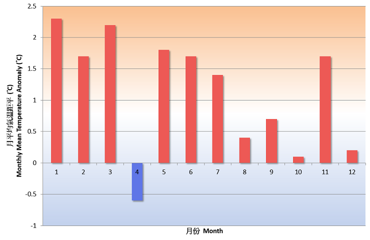
Fig.1 Monthly mean temperature anomalies (against the 1981-2010 normal) in Hong Kong in 2020
The annual total rainfall in 2020 was 2,395.0 millimetres, near the 1981-2010 normal of 2,398.5 millimetres. Eleven red rainstorm warnings and two black rainstorm warnings were issued by the Hong Kong Observatory in the year. The number of days with thunderstorms reported in Hong Kong was 42 days in 2020, about 3 days more than the 1981-2010 normal.
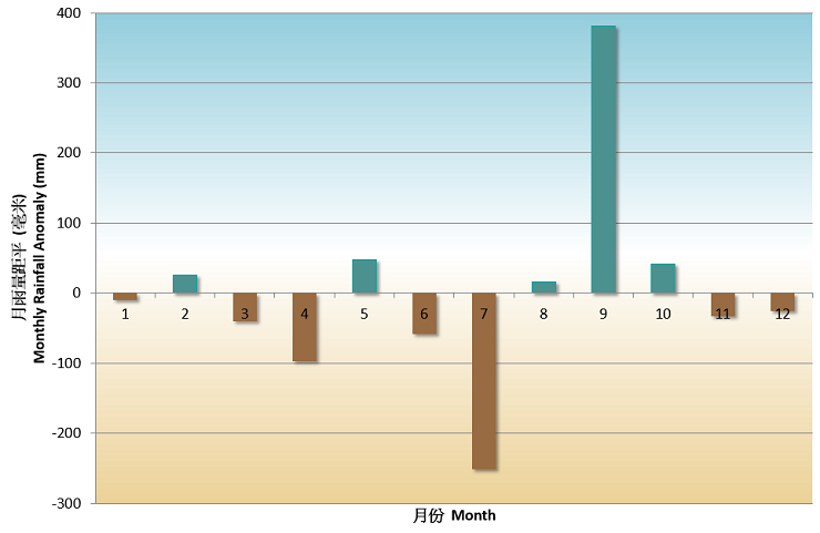
Fig. 6 Monthly rainfall anomalies (against the 1981-2010 normal) in Hong Kong in 2020
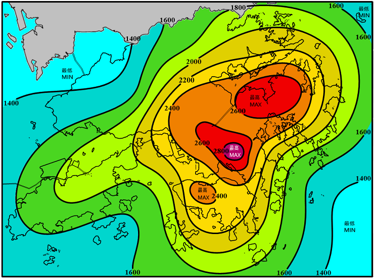
Fig.7 Annual rainfall distribution in Hong Kong in 2020 (in mm)
A total of 25 tropical cyclones occurred over the western North Pacific and the South China Sea in 2020, less than the long-term (1961-2010) average of about 30. There were 11 tropical cyclones reaching typhoon intensity[5] or above during the year, less than the long-term average of about 15, and three of them reached super typhoon intensity (with maximum 10-minute wind speed of 185 km/h or above near the centre). In Hong Kong, five tropical cyclones necessitated the issuance of tropical cyclone warning signals, slightly less than the long-term average of about six in a year. The Increasing Gale or Storm Signal, No. 9 was issued during the passage of Higos in August, while the No. 8 Gale or Storm Signal was issued during the passage of Nangka in October.
Detailed description of the weather for individual months is available on the Monthly Weather Summary webpage:
https://www.weather.gov.hk/en/wxinfo/pastwx/mws/mws.htm
Some significant weather events in Hong Kong in 2020 are highlighted below:
Warmest January
2020 commenced with the warmest January on record in Hong Kong. The mean maximum temperature of 21.2 degrees and mean temperature of 18.6 degrees of January 2020 were respectively 2.6 degrees and 2.3 degrees above their corresponding normals and both were the highest on record for January.
Warmest first half year
The first half of 2020 from January to June was exceptionally warm in Hong Kong. The mean maximum temperature of 25.7 degrees and mean temperature of 23.0 degrees were respectively 1.9 degrees and 1.6 degrees above their corresponding normals. Both were the highest on record for the same period.
Hottest summer
With scorching weather persisting in June and July 2020, the summer from June to August 2020 was extremely hot in Hong Kong. The mean maximum temperature of 32.6 degrees, mean temperature of 29.6 degrees and mean minimum temperature of 27.7 degrees were respectively 1.7 degrees, 1.2 degrees and 1.2 degrees above their corresponding normals and all of them were the highest on record for summer.
Moreover, the record-breaking high temperatures in July 2020 made it the hottest month in Hong Kong since records began in 1884. The monthly mean maximum temperature of 33.3 degrees, monthly mean temperature of 30.2 degrees and monthly mean minimum temperature of 28.3 degrees were respectively 1.9 degrees, 1.4 degrees and 1.5 degrees above their corresponding normals and all of them were the highest on record.
Record breaking number of Hot Nights and Very Hot Days
The unrelenting heat in summer 2020 also set the following new records for the number of very hot days and hot nights in Hong Kong :
- The monthly total of 18 hot nights in June 2020 was the highest on record for June;
- The monthly total of 20 very hot days and 21 hot nights in July 2020 were both the all-time high on record;
- The 11 consecutive hot nights that started from 5 July 2020 set a new record for July
- The 13 consecutive hot nights from 19 June to 1 July 2020 was the longest on record;
- The monthly total of 16 very hot days in August 2020 was the highest on record for August;
and
- There were in total 50 Hot Nights and 47 Very Hot Days in 2020. Both were the highest annual numbers on record.
The rainstorm on 6 June
Affected by a trough of low pressure lingering over the coastal areas of Guangdong, heavy showers and intense squally thunderstorms brought frequent lightning, heavy rain and severe squalls to Hong Kong on the morning of 6 June 2020. The incessant downpour necessitated the issuance of the Black Rainstorm Warning, the first time since May 2017. Most parts of the territory recorded over 100 millimetres of rainfall on that day and the rainfall in some areas even exceeded 200 millimetres. Moreover, more than 14,350 cloud-to-ground lightning strokes were detected in Hong Kong on that day, the second highest on record since the launch of the lightning location system in 2005.

The strike of Typhoon Higos
Developed over the northeastern part of South China Sea, tropical cyclone Higos moved towards the Pearl River Estuary and rapidly intensified into a typhoon on the night of 18 August 2020 right before making landfall on the morning of 19 August 2020. Packing high winds and heavy rain, the strike of Higos necessitated the issuance of the Increasing Gale or Storm Signal No. 9 in Hong Kong on 19 August 2020. The eye wall of Higos, where sustained hurricane force winds were recorded, was very close to the southwestern part of Hong Kong on the early morning of 19 August 2020. Storm force and hurricane force winds were respectively recorded over offshore and on some of the high ground at that time. Heavy squally showers and thunderstorms associated with Higos also brought more than 150 millimetres of rainfall to most parts of Hong Kong on 18 and 19 August 2020.
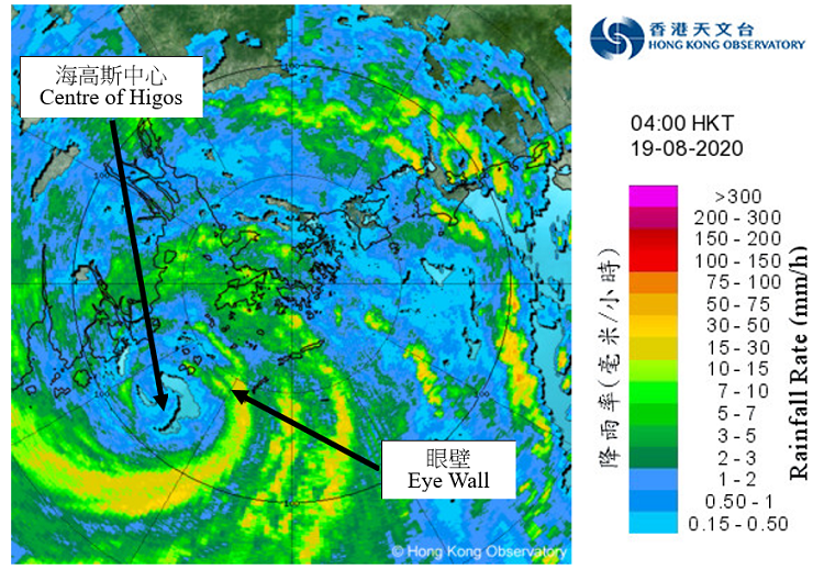 Fig. 9 Image of radar echoes at 4 a.m. on 19 August 2020. The eye wall of Higos was very close to the southwestern part of Hong Kong. The eye wall is the inner most ring of convection near the centre of a typhoon, containing most intense winds and heavy rain. Sustained hurricane force winds were recorded at the area covered by the eye wall at that time.
Intense cold surge at the end of December
With a cold front moving across the south China coast on 29 December, the associated intense cold surge brought significantly colder weather to Hong Kong on 30 December. The weather became cold, windy and very dry on 31 December with the temperature at the Observatory falling to 8.1 degrees in the morning, the lowest of the year. The temperature at Tai Mo Shan even dropped to -1.2 degrees on that morning.
Notes :
[1] Climatological normals for the reference period of 1961-1990, 1971-2000 and 1981-2010 are available at : https://www.weather.gov.hk/en/cis/normal.htm Climatological normals of 1981-2010 are referenced in the text unless otherwise stated.
[2] 'Hot Night' refers to the condition with the daily minimum temperature equal to or higher than 28.0 degrees.
[3] 'Very Hot Day' refers to the condition with the daily maximum temperature equal to or higher than 33.0 degrees.
[4] 'Cold Day' refers to the condition with the daily minimum temperature equal to or lower than 12.0 degrees.
[5] Information on the classification of Tropical Cyclones is available at: https://www.weather.gov.hk/en/informtc/class.htm
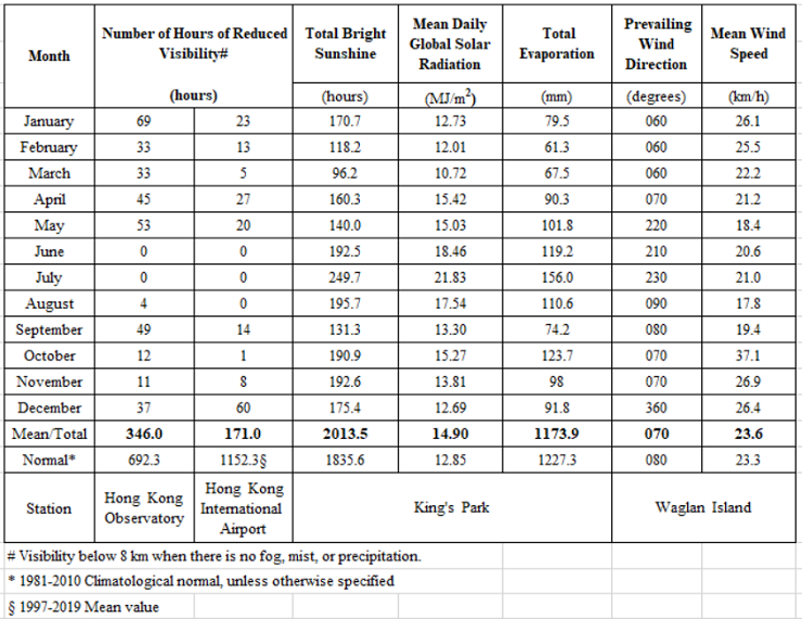
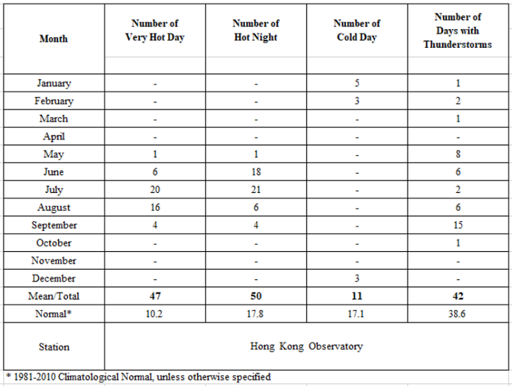
Table 2c Summary of meteorological observations in Hong Kong, 2020
Globally, 2020 is on track to be one of the three warmest years on record according to the World Meteorological Organization's preliminary assessment. Over the Arctic, the sea-ice extents for July and October 2020 were the lowest on record and the annual minimum in September was also the second lowest. In 2020, various extreme weather events continued to wreak havoc in different parts of the world, including heatwaves in the Australia, Caribbean region, Mexico, South America, western Europe, eastern Mediterranean, Japan, and Siberia; extreme cold events in North America and the southern part of South America; severe drought in the interior of South America, north-central Europe and parts of the southern Africa; extreme rainfall triggered severe flooding in large parts of Africa, South Asia, China, Korean Peninsula, Viet Nam and parts of western Japan; and severe damages and heavy casualties brought by tropical cyclones in the United States, Caribbean region, Central America, India, Bangladesh, Fiji, Vanuatu, the Philippines, Korean Peninsula, western Japan and Viet Nam. Exacerbating by widespread drought and high temperature weather, destructive wildfires ravaged California and Colorado of the United States, northern Siberia, eastern Australia, and western Brazil.
A weak El Niño event was established in April 2020. However, sea surface temperatures of the central and eastern equatorial Pacific dropped rapidly afterwards, returning to normal in May. The cooling trend continued into the second half of the year. Sea surface temperatures of the central and eastern equatorial Pacific became below normal in September and remained colder than normal till the end of the year, indicating the development of a La Niña event.
In Hong Kong, with eleven out of the twelve months warmer than usual, 2020 was the second warmest year since records began in 1884 with an annual mean temperature of 24.4 degrees, 1.1 degrees above the 1981-2010 normal[1]. The annual mean maximum temperature of 27.2 degrees and annual mean minimum temperature of 22.5 degrees were respectively the highest and second highest on record. In particular, the mean temperature, the mean maximum temperature and the mean minimum temperature for summer (June to August) respectively reached 29.6 degrees, 32.6 degrees and 27.7 degrees, all ranking the highest on record. The highest temperature recorded at the Hong Kong Observatory in the year was 35.3 degrees on 23 July, one of the twelfth highest on record. There were 50 Hot Nights[2] and 47 Very Hot Days[3] in Hong Kong in 2020, both ranking the highest on record.
The lowest temperature recorded at the Hong Kong Observatory in the year was 8.1 degrees on 31 December. The number of Cold Days[4] in the year was 11 days, which is 6.1 days less than the 1981-2010 normal.
Fig.1 Monthly mean temperature anomalies (against the 1981-2010 normal) in Hong Kong in 2020
Fig.2 Long-term time series of number of Hot Nights in Hong Kong 1884-2020
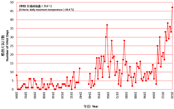
Fig.3 Long-term time series of number of Very Hot Days in Hong Kong 1884-2020
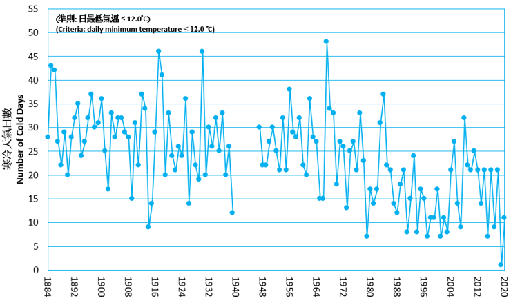
Fig.4 Long-term time series of number of Cold Days in Hong Kong 1884-2020
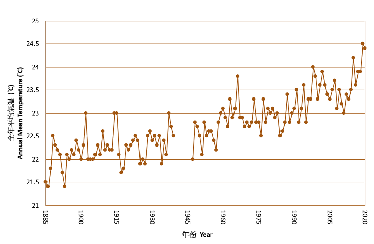
Fig. 5 Long-term time series of annual mean temperature in Hong Kong 1885-2020
The annual total rainfall in 2020 was 2,395.0 millimetres, near the 1981-2010 normal of 2,398.5 millimetres. Eleven red rainstorm warnings and two black rainstorm warnings were issued by the Hong Kong Observatory in the year. The number of days with thunderstorms reported in Hong Kong was 42 days in 2020, about 3 days more than the 1981-2010 normal.
Fig. 6 Monthly rainfall anomalies (against the 1981-2010 normal) in Hong Kong in 2020
Fig.7 Annual rainfall distribution in Hong Kong in 2020 (in mm)
A total of 25 tropical cyclones occurred over the western North Pacific and the South China Sea in 2020, less than the long-term (1961-2010) average of about 30. There were 11 tropical cyclones reaching typhoon intensity[5] or above during the year, less than the long-term average of about 15, and three of them reached super typhoon intensity (with maximum 10-minute wind speed of 185 km/h or above near the centre). In Hong Kong, five tropical cyclones necessitated the issuance of tropical cyclone warning signals, slightly less than the long-term average of about six in a year. The Increasing Gale or Storm Signal, No. 9 was issued during the passage of Higos in August, while the No. 8 Gale or Storm Signal was issued during the passage of Nangka in October.
Detailed description of the weather for individual months is available on the Monthly Weather Summary webpage:
https://www.weather.gov.hk/en/wxinfo/pastwx/mws/mws.htm
Some significant weather events in Hong Kong in 2020 are highlighted below:
Warmest January
2020 commenced with the warmest January on record in Hong Kong. The mean maximum temperature of 21.2 degrees and mean temperature of 18.6 degrees of January 2020 were respectively 2.6 degrees and 2.3 degrees above their corresponding normals and both were the highest on record for January.
Warmest first half year
The first half of 2020 from January to June was exceptionally warm in Hong Kong. The mean maximum temperature of 25.7 degrees and mean temperature of 23.0 degrees were respectively 1.9 degrees and 1.6 degrees above their corresponding normals. Both were the highest on record for the same period.
Hottest summer
With scorching weather persisting in June and July 2020, the summer from June to August 2020 was extremely hot in Hong Kong. The mean maximum temperature of 32.6 degrees, mean temperature of 29.6 degrees and mean minimum temperature of 27.7 degrees were respectively 1.7 degrees, 1.2 degrees and 1.2 degrees above their corresponding normals and all of them were the highest on record for summer.
Moreover, the record-breaking high temperatures in July 2020 made it the hottest month in Hong Kong since records began in 1884. The monthly mean maximum temperature of 33.3 degrees, monthly mean temperature of 30.2 degrees and monthly mean minimum temperature of 28.3 degrees were respectively 1.9 degrees, 1.4 degrees and 1.5 degrees above their corresponding normals and all of them were the highest on record.
Record breaking number of Hot Nights and Very Hot Days
The unrelenting heat in summer 2020 also set the following new records for the number of very hot days and hot nights in Hong Kong :
- The monthly total of 18 hot nights in June 2020 was the highest on record for June;
- The monthly total of 20 very hot days and 21 hot nights in July 2020 were both the all-time high on record;
- The 11 consecutive hot nights that started from 5 July 2020 set a new record for July
- The 13 consecutive hot nights from 19 June to 1 July 2020 was the longest on record;
- The monthly total of 16 very hot days in August 2020 was the highest on record for August;
and
- There were in total 50 Hot Nights and 47 Very Hot Days in 2020. Both were the highest annual numbers on record.
The rainstorm on 6 June
Affected by a trough of low pressure lingering over the coastal areas of Guangdong, heavy showers and intense squally thunderstorms brought frequent lightning, heavy rain and severe squalls to Hong Kong on the morning of 6 June 2020. The incessant downpour necessitated the issuance of the Black Rainstorm Warning, the first time since May 2017. Most parts of the territory recorded over 100 millimetres of rainfall on that day and the rainfall in some areas even exceeded 200 millimetres. Moreover, more than 14,350 cloud-to-ground lightning strokes were detected in Hong Kong on that day, the second highest on record since the launch of the lightning location system in 2005.
Fig. 8 Serious flooding in Kwun Tong Road on the morning of 6 June 2020
The strike of Typhoon Higos
Developed over the northeastern part of South China Sea, tropical cyclone Higos moved towards the Pearl River Estuary and rapidly intensified into a typhoon on the night of 18 August 2020 right before making landfall on the morning of 19 August 2020. Packing high winds and heavy rain, the strike of Higos necessitated the issuance of the Increasing Gale or Storm Signal No. 9 in Hong Kong on 19 August 2020. The eye wall of Higos, where sustained hurricane force winds were recorded, was very close to the southwestern part of Hong Kong on the early morning of 19 August 2020. Storm force and hurricane force winds were respectively recorded over offshore and on some of the high ground at that time. Heavy squally showers and thunderstorms associated with Higos also brought more than 150 millimetres of rainfall to most parts of Hong Kong on 18 and 19 August 2020.
Intense cold surge at the end of December
With a cold front moving across the south China coast on 29 December, the associated intense cold surge brought significantly colder weather to Hong Kong on 30 December. The weather became cold, windy and very dry on 31 December with the temperature at the Observatory falling to 8.1 degrees in the morning, the lowest of the year. The temperature at Tai Mo Shan even dropped to -1.2 degrees on that morning.
Notes :
[1] Climatological normals for the reference period of 1961-1990, 1971-2000 and 1981-2010 are available at : https://www.weather.gov.hk/en/cis/normal.htm Climatological normals of 1981-2010 are referenced in the text unless otherwise stated.
[2] 'Hot Night' refers to the condition with the daily minimum temperature equal to or higher than 28.0 degrees.
[3] 'Very Hot Day' refers to the condition with the daily maximum temperature equal to or higher than 33.0 degrees.
[4] 'Cold Day' refers to the condition with the daily minimum temperature equal to or lower than 12.0 degrees.
[5] Information on the classification of Tropical Cyclones is available at: https://www.weather.gov.hk/en/informtc/class.htm
Table 1 Summary of record-breaking high temperature events in 2020
| Record-breaking Events (since records began in 1884) |
Date / Period | New Record |
| 1. Highest Mean Max Temperature for January | January 2020 | 21.2℃ |
| 2. Highest Mean Temperature for January | January 2020 | 18.6℃ |
| 3. Highest Mean Max Temperature for winter | December 2019 to February 2020 | 21.5℃ |
| 4. Highest Monthly Absolute Min Temperature for March | March 2020 | 16.5℃ |
| 5. Highest Mean Min Temperature for June | June 2020 | 27.8℃ |
| 6. Highest Number of Hot Nights for June | June 2020 | 18 Days |
| 7. Highest Number of Consecutive Hot Nights for June | June 2020 | 12 Days |
| 8. Highest Number of Consecutive Hot Nights | 19 June to 1 July 2020 | 13 Days |
| 9. Highest Mean Max Temperature for the first half of year | January to June 2020 | 25.7℃ |
| 10. Highest Mean Temperature for the first half of year* | January to June 2020 | 23.0℃ |
| 11. Highest Mean Max Temperature for July | July 2020 | 33.3℃ |
| 12. Highest Mean Temperature for July | July 2020 | 30.2℃ |
| 13. Highest Mean Min Temperature for July | July 2020 | 28.3℃ |
| 14. Highest Mean Max Temperature for All Months | July 2020 | 33.3℃ |
| 15.Highest Mean Temperature for All Months | July 2020 | 30.2℃ |
| 16. Highest Mean Min Temperature for All Months | July 2020 | 28.3℃ |
| 17. Highest Number of Consecutive Hot Nights for July | July 2020 | 11 Days |
| 18. Highest Number of Hot Nights for July | July 2020 | 21 Days |
| 19. Highest Number of Hot Nights for All Months | July 2020 | 21 Days |
| 20. Highest Number of V Hot Days for July | July 2020 | 20 Days |
| 21. Highest Number of V Hot Days for All Months | July 2020 | 20 Days |
| 22. Longest Duration of V Hot Warning | 11 July 2020 to 30 July 2020 | 467 Hours |
| 23. Highest Mean Maximum Temperature for summer | June to August 2020 | 32.6℃ |
| 24. Highest Mean Temperature for summer | June to August 2020 | 29.6℃ |
| 25. Highest Mean Minimum Temperature for summer | June to August 2020 | 27.7℃ |
| 26. Highest Number of V Hot Days for August | August 2020 | 16 Days |
| 27. Highest Daily Maximum Temperature for Winter Commences | 7 November 2020 | 30.2℃ |
| 28. Highest Annual Number of V Hot Days | 2020 | 47 Days |
| 29. Highest Annual Number of Hot Nights | 2020 | 50 Days |
| 30. Highest Annual Mean Maximum Temperature | 2020 | 27.2℃ |
* Joint highest record with January to June 2019
Table 2a Summary of meteorological observations in Hong Kong, 2020
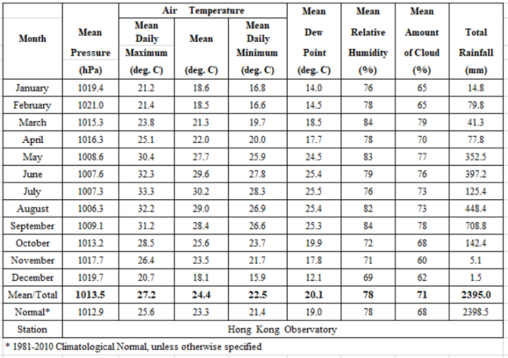
Table 2b Summary of meteorological observations in Hong Kong, 2020
Table 2b Summary of meteorological observations in Hong Kong, 2020
Table 2c Summary of meteorological observations in Hong Kong, 2020