潛在影響香港的南海海嘯源風險評估
潛在影響香港的南海海嘯源風險評估
![圖1 南中國海區域海嘯源示意圖,以及香港有感地震的震中位置(包含1979年之前香港可能有感地震的不完整記錄[2,3] 及自短週期地震站監測網1979年建立以來至2025年8月為止香港有感地震[4] )。](../../../tc/gts/equake/images/Littoral Fault Zone with Earthquake Felt in Hong Kong since 1900_tc.png)
圖1 南中國海區域海嘯源示意圖,以及香港有感地震的震中位置(包含1979年之前香港可能有感地震的不完整記錄[2,3] 及自短週期地震站監測網1979年建立以來至2025年8月為止香港有感地震[4] )。
馬尼拉海溝

圖2 (上) 菲律賓海板塊俯衝至歐亞板塊之下,應力在兩塊板塊之間積累;(下) 歐亞板塊回彈以釋放累積的應力,產生地震及海嘯。
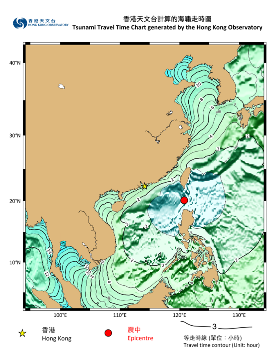
圖3 根據香港天文台計算,若馬尼拉海溝北端發生地震,海嘯到達近岸所需的傳播時間(海嘯走時)。
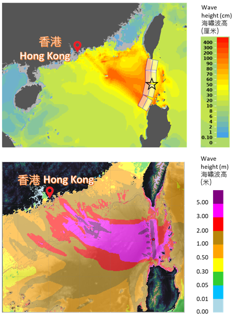
圖4 假設馬尼拉海溝發生8.6級淺層大地震,由美國TsuCAT程式(上圖)及香港天文台海嘯模式(下圖)輸出的海嘯波高預測。
濱海斷裂帶與陸坡斷裂帶
海底滑坡
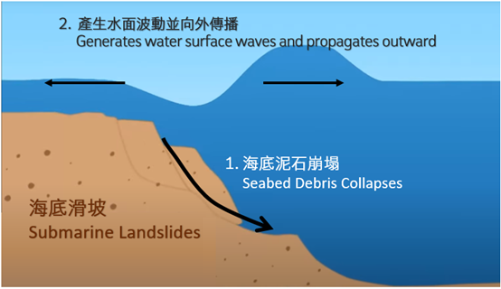
圖5 海底滑坡產生海嘯的機制。
結語
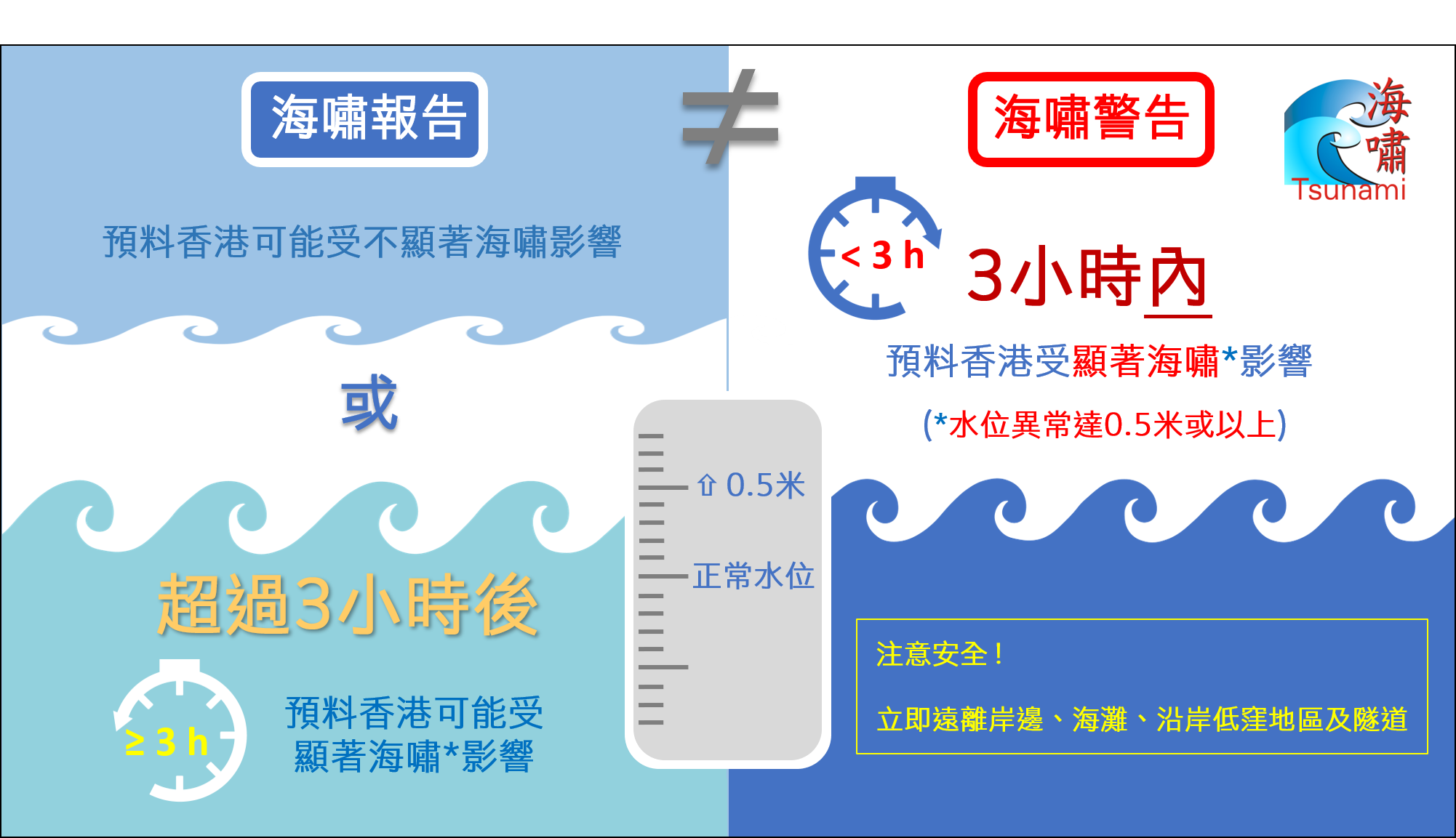
圖6 海嘯報告和海嘯警告不同之處的示意圖。
參考資料:
[1] UNESCO (2022). Standard guidelines for the Tsunami Ready Recognition Programme.[只有英文版]
[2] GEO (2012). Review of Earthquake Data for the Hong Kong Region. Publication No.1/2012.[只有英文版]
[3] Chau, M.S. & Tse, S.K. (1988). Earthquakes felt in Hong Kong since 1900. HKO’s internal document.
[4] 香港天文台「1979年以來的本地有感地震」網頁
[5] Hsu, Y. J., Yu, S. B., Song, T. R. A. & Bacolcol, T. (2012). Plate coupling along the Manila subduction zone between Taiwan and northern Luzon. Journal of Asian Earth Sciences, 51, 98-108.
[6] Hsu, Y. J., Yu, S. B., Loveless, J. P., Bacolcol, T., Solidum, R., Luis Jr, A., Pelicano, A. & Woessner, J. (2016). Interseismic deformation and moment deficit along the Manila subduction zone and the Philippine Fault system. Journal of Geophysical Research: Solid Earth, 121(10), 7639-7665.
[7] Yu, H., Liu, Y., Yang, H. & Ning, J. (2018). Modeling earthquake sequences along the Manila subduction zone: Effects of three-dimensional fault geometry. Tectonophysics, 733, 73-84.
[8] Li, L., Switzer, A. D., Chan, C. H., Wang, Y., Weiss, R. & Qiu, Q. (2016). How heterogeneous coseismic slip affects regional probabilistic tsunami hazard assessment: A case study in the South China Sea. Journal of Geophysical Research: Solid Earth, 121(8), 6250-6272.
[9] Sepúlveda, I., Liu, P. L.-F. & Grigoriu, M. (2019). Probabilistic tsunami hazard assessment in South China Sea with consideration of uncertain earthquake characteristics. Journal of Geophysical Research: Solid Earth, 124(1), 658-688.
[10] Qiu, Q., Li, L., Hsu, Y. J., Wang, Y., Chan, C. H. & Switzer, A. D. (2019). Revised earthquake sources along Manila trench for tsunami hazard assessment in the South China Sea. Natural Hazards and Earth System Sciences, 19(7), 1565-1583.
[11] Okal, E. A., Synolakis, C. E. & Kalligeris, N. (2011). Tsunami simulations for regional sources in the South China and adjoining seas. Pure and Applied Geophysics, 168(6), 1153-1173.
[12] 美國國家海洋和大氣管理局海嘯研究中心海嘯海岸評估工具(TsuCAT)網頁.
[13] 土木工程拓展署土力工程處 (2025) 參考便覽 第21/2025號 《香港的地震活動》
[14] Li, L., Qiu, Q., Li, Z., & Zhang, P. (2022). Tsunami hazard assessment in the South China Sea: A review of recent progress and research gaps. Science China Earth Sciences, 65(5), 783-809.
[15] GEO (2015). Seismic Hazard Analysis of the Hong Kong Region. GEO Report No. 311. [只有英文版]
[16] Dai, X., Li, Z., Hu, L., Zhang, P., Yang, X., Almeida, R. & Li, G. (2024). Exploring fault geometry and Holocene deformation of the Littoral Fault Zone within the seismic gap south of Greater Bay Area, China. Journal of Marine Science and Engineering, 12(8), 1350.
[17] Li, X., Wang, Z., Li, Y., Yu, H., Zhang, Z., Zhang, W. & Chen, X.. Rupture dynamics of the middle section of Littoral Fault Zone: Potential maximum magnitude and cascading rupture analysis. Seismological Research Letters, 96 (5), 2916–2927.
[18] 丁原章 (2004). 廣東與香港地震風險概論. 商務印書館 (香港) 有限公司.
[19] Zhu, Y., An, C., Yu, H., Zhang, W. & Chen, X. (2024). High-resolution tsunami hazard assessment for the Guangdong-Hong Kong-Macao Greater Bay Area based on a non-hydrostatic tsunami model. Science China Earth Sciences, 67(7), 2326-2351.
[20] Liu, Y., Ren, Y., Wen, R. & Wang, H. (2021). Probabilistic tsunami hazard assessment for the southeast coast of China: Consideration of both regional and local potential sources. Pure and Applied Geophysics, 178(12), 5061-5084.
[21] Lv, L., Li, Z., Wang, D., Wang, W., Dai, X., Zeng, F., Li, L., Liang, H., Hui, G., Long, W. & Zhang, P. (2024). The latest activity of the slope fault zone (Pearl River Mouth) in northern South China Sea and implications for earthquake hazard assessments. Marine and Petroleum Geology, 166, 106937.
[22] Li, L., Shi, F., Ma, G. & Qiu, Q. (2019). Tsunamigenic potential of the Baiyun slide complex in the South China Sea. Journal of Geophysical Research: Solid Earth, 124(8), 7680-7698.