飛 行 氣 象
 |
| 航空界通訊 |
|
第十八期 二零零二年十二月 |
新產品及服務發展
_____________________________________
天文台榮獲全球第一

劉心怡
香港天文台成為全球第一批獲頒發在國際航空服務方面的ISO 9001認證的氣象服務單位之一。
根據國際民用航空組織在二零零一年的建議,天文台為航空氣象服務進行ISO認證。程序首先聘請「羅氏管理顧問公司」在二零零一年底提供所需的培訓,
然後在二零零二年初建立一套品質管理的文件及系統。天文台繼而委任 Bureau Veritas Quality International (BVQI) 為認證機構,
並在二零零二年年中進行內部審核,終於在今年十月成功完成整個認證的審核。
香港天文台台長林鴻鋆博士說﹕「天文台能夠成為全球第一批獲得
ISO認證的航空氣象服務單位之一,實在是有賴同事們的合作和努力不懈,以及各航空用戶對我們的服務所提出的建設性意見。」
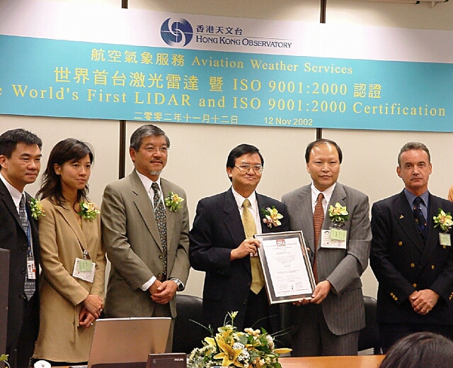
圖 1 : 天文台台長林鴻鋆博士(右三) 在航空界代表前接受BVQI 代表王建飛先生所頒發的ISO證書
首台「激光雷達」
李淑明
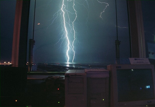
在二零零二年六月底的一個晚上,香港天文台在空中交通管制大樓的天台上順利安裝了一套激光雷達, 這是世界上第一台用於機場天氣預警的激光雷達。
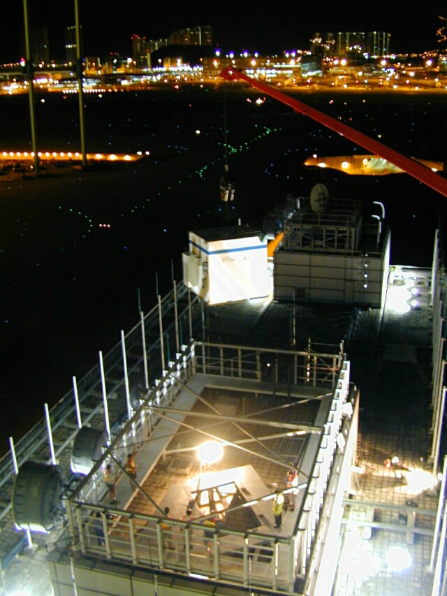
圖 2 : 起重機將激光雷達的儀器外罩吊到空中交通管制大樓的天台
過往,天文台利用機場多普勒天氣雷達來探測香港國際機場附近的風切變。機場多普勒天氣雷達運用微波, 測量空氣中水點的移動速度,以計算風向及風速資料,在雨天情況下能有效地探測風切變。新安裝的激光雷達則利用紅外線探測空氣中塵粒 和微細粒子的移動,在無雨情況下最能發揮作用,即使肉眼看不到的天氣現象也無所遁形。在激光雷達和機場多普勒天氣雷達相輔相成的配合下, 探測風切變將更全面。
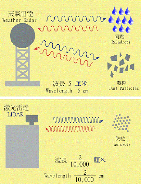
圖 3: 天氣雷達與激光雷達運作原理的分別
激光雷達位於香港國際機場兩條平行的跑道之間,不斷掃瞄機場的升降區,以探測可能影響飛機升降的氣流, 覆蓋範圍遠至跑道著陸區外3海里(5.6公里)。雖然激光雷達現正作試驗性運行,到目前為止,它已探測到一些有趣的個案,例如由海風引起的風切變、 與熱帶氣旋相關的風切變等。天文台將要收集一段時間的數據進行分析,以優化軟件功能,計劃激光雷達於二零零五年投入業務運作。
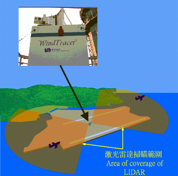
圖 4: 激光雷達掃瞄範圍示意圖
為機師編撰的小冊子
鄭楚明
天文台與國際航空公司飛行員協會合作編撰了一本有關風切變及湍流的小冊子,內容包括風切變及湍流的資料、 它們的成因和香港的風切變及湍流預警服務,以供飛機師參考。為方便向機師和其他有興趣的讀者廣泛推介,天文台已將小冊子放在互聯網上供下載。
更多氣象產品
李聯安
航空公司用戶現在可以透過航空氣象資料發放系統選取更多的天氣產品,其中包括:
|
|
以風羽圖像顯示的香港國際機場風向和風速資料 |
 |
本港多個地區的風向和風速資料 |
|
亞太區、歐洲及非洲等地區的機場天氣報告和預報 |
|
「歐洲衛星組織的地球同步衛星(Meteosat-5)」及「美國國家海洋及大氣管理局的極地軌道氣象衛星系列 (NOAA-12、14、15及16號)」的氣象衛星圖片。 |
圖 5: 以風羽圖像顯示的香港國際機場風向和風速資料
圖 6: 亞太區、歐洲及非洲等地區的機場天氣報告和預報
The LIDAR is coming!
Captain Brian Greeves
(Hong Kong Airline Pilots Association)
(This article is reproduced from Flyleaf - Issue 42 with the permission from HKAOA/ HKALPA and Captain Brain Greeves)
「激光雷達的來臨」- 轉載自 Flyleaf - Issue 42 (只以英文發表)
Flyleaf is a magazine published by the Hong Kong Aircrew Officers Association (HKAOA) and the Hong Kong Airline Pilots Association (HKALPA).
In the following article published in August 2002, shortly after installation of the LIDAR, Captain Greeves gives us an introduction of the
LIDAR and his perception of the equipment from a pilot's perspective.
In my last article (Flyleaf - Issue 41) on the Windshear and Turbulence Warning System, I promised to
write something about the LIDAR. I hoped that everyone had forgotten that, but unfortunately I received a note from the
editor demanding a piece, so here goes!
First of all, LIDAR is not a new type of lie detection equipment. It stands for
LIght Detection and Ranging and is a type of infrared Doppler radar. It works in a similar way as a Doppler weather radar such
as the TDWR, but uses an invisible (and safe) laser beam instead of microwaves. Its range of detection is limited by both the line
of sight and by the visibility, so whilst the TDWR works best with particles, particularly raindrops, the LIDAR works best in clear
skies with very small particles (aerosols).
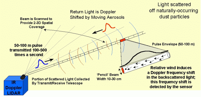
Figure 7 : Infrared Doppler radar (LIDAR) principle of operation
The wavelength of the LIDAR beam is 2 microns compared with 5 cm for the TDWR. This is not a limitation, because it has been bought to assist with the detection of windshear and turbulence in clear air conditions.
It will be sited on top of the ATC Complex and will have a range of about 4.5 nm. It will be able to observe the approach/departure track of all the runways i.e. out to 3nm beyond each runway threshold. This is one of the first installations of an operational LIDAR. Although the LIDAR has been around for sometime, it has previously only been used for research projects/purposes, including determining the wind characteristics around Chek Lap Kok prior to the opening of the Hong Kong International Airport. The problem with these research LIDARs was the scan rate was very slow (about once per 30 minutes) so they were no good for giving real-time information. This LIDAR will not have that limitation. It is still too early to know what its exact performance will be, but if it works, as planned, it will prove to be an excellent enhancement to the WTWS.
The LIDAR will be installed this summer and should be providing data towards the end of the year. Initially, the performance of the LIDAR will be assessed by the Hong Kong Observatory (HKO). It will then be gradually integrated (in 2003), first to assist the forecaster, with the eventual aim of it generating automatic alerts (2005 provisionally).
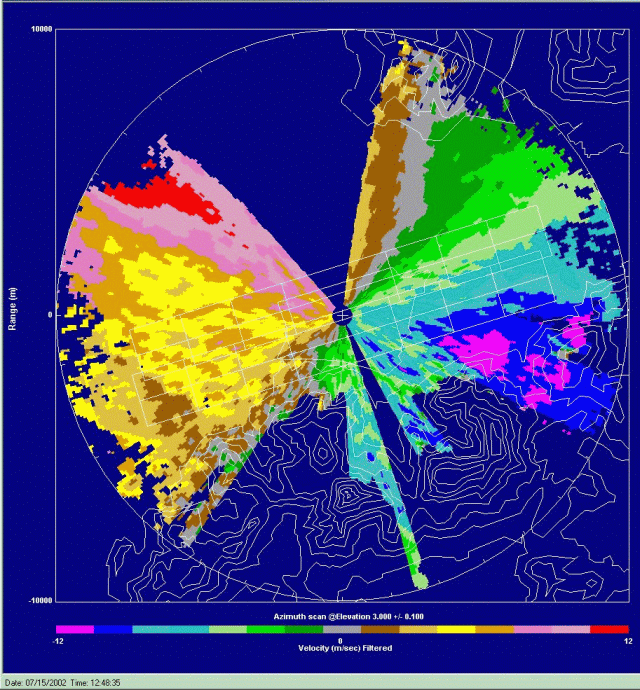
Figure 8: LIDAR wind velocities
The LIDAR is already producing some good data, including the above radar picture showing turbulence with around 5-10 knots loss on the approach to Runway 07. The TDWR (see display below) was taken slightly earlier, when an alert was being generated with a 10-15 knots loss. I know the LIDAR was correct, because I flew the approach at that time.
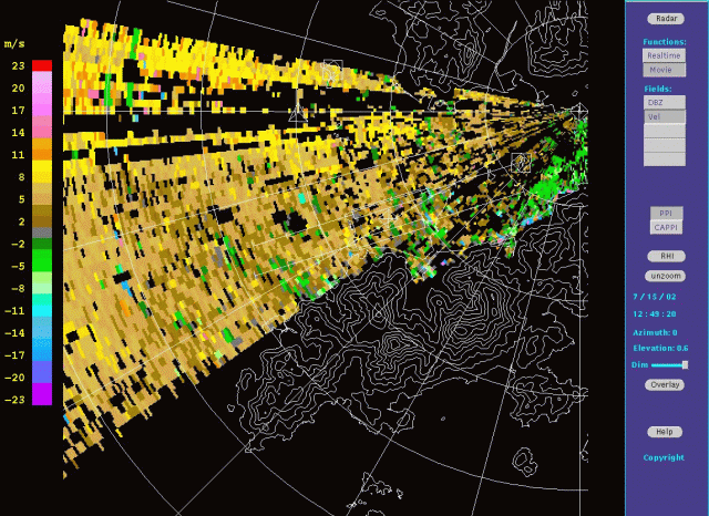
Figure 9: TDWR wind velocities
全球天氣
馬偉民
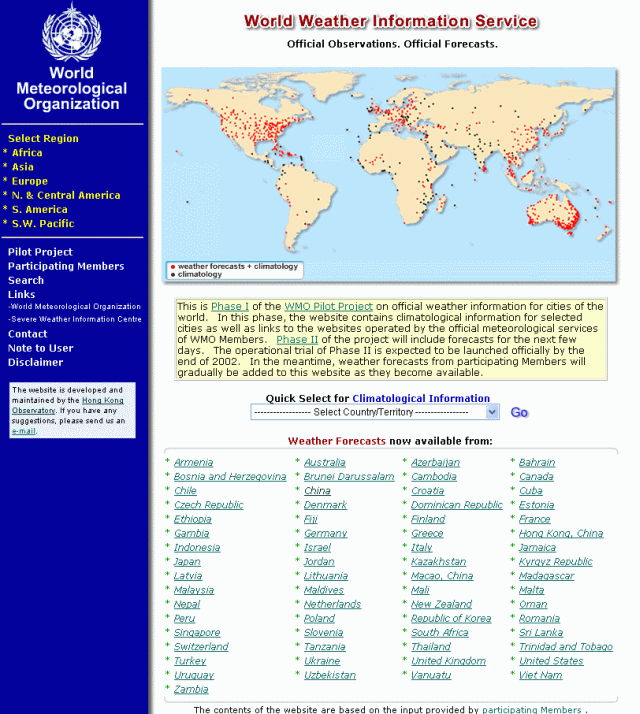
香港天文台獲得世界氣象組織委託,負責開發及管理兩個涵蓋全球天氣資訊的實驗網站,以鼓勵各地傳媒及公眾使用
各國氣象局的天氣資料。
「世界天氣資訊服務」網站提供各地城市的天氣資料,第一階段主要提供氣候數據,已於去年十二月開始運作。
第二階段加入了各地的城市天氣預報,在二零零二年十二月正式開始投入服務。目前該網站已包含了超過600個城市的預報和800個城市的氣候資料。
資料都是由各國氣象局提供的,所以質素都有一定保證。市民如想進一步了解當地的天氣情況,更可以透過網站內的連結,瀏覽有關氣象局網站。
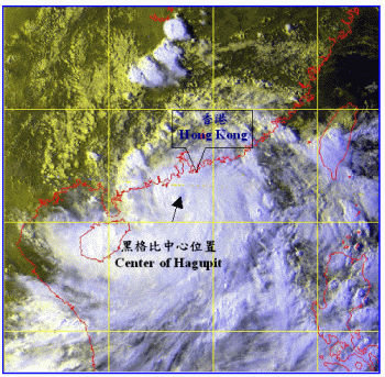
另一個網站 -「惡劣天氣信息中心」則專責提供世界各地惡劣天氣方面的資訊。這個網站初期提供西北太平洋地區各國氣象局 發出的區內熱帶氣旋預報和警告。最近網站的覆蓋範圍已擴展到西南太平洋地區(如澳洲、紐西蘭、斐濟等)。九月十一日強烈熱帶風暴黑格比橫過南海時, 網站瀏覽數目超過四萬次。
機場天氣觀測
_____________________________________
赤鱲角的煙霞
呂永康
最近城中的熱門話題是煙霞導致香港能見度下降,有多處地方受影響,例如位於大嶼山的東涌。
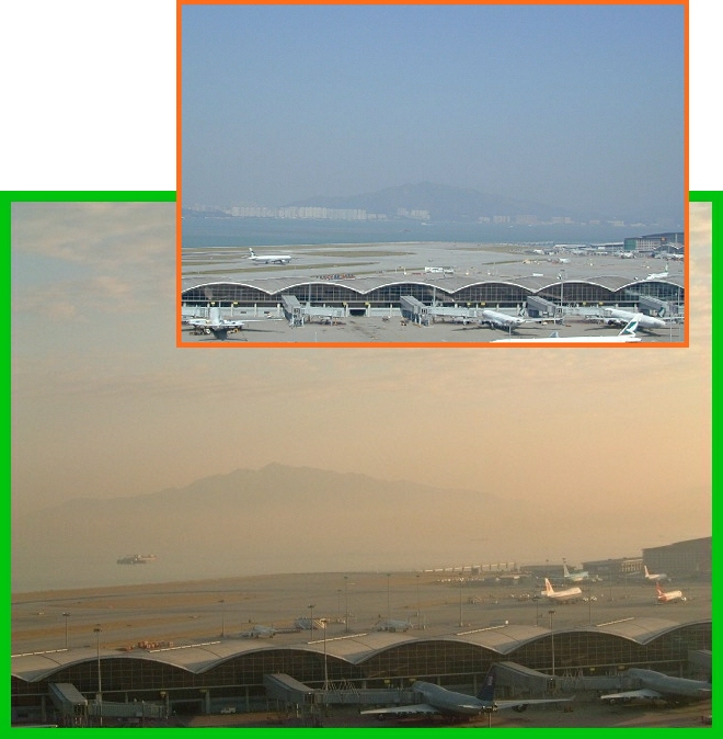
圖 12: 二零零一年一月赤鱲角出現煙霞的情況,
照片是朝北面向青山拍攝。小圖為天朗氣清下的照片。
煙霞是指由空氣中的微細塵埃或懸浮粒子所引起的能見度下降的情況。以上的照片比較在大嶼山赤鱲角有煙霞出現和天朗氣清時的景物。
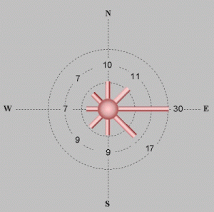
讓我們看看赤鱲角與煙霞相關的天氣情況。天文台的天氣觀測員在赤鱲角每小時進行一次天氣觀測。圖13赤鱲角的風分佈圖顯示風向以來自東面為主。
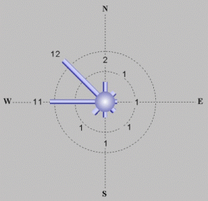
雖然西風和西北風出現的時間比較少,但對比其他風向發生煙霞的機會則異常地高。圖14可以清楚顯示這個情況。圖中表示在各個風向煙霞發生的時間百分比, 當風由西或西北面吹來,有十分之一機會出現煙霞。
|
|
|
||||
|
|
雲的網頁
劉心怡、劉迪森
你有否留意天空上的雲能夠有千變萬化的形狀?對飛機師來說,雲可以預示未來的天氣。根據高度及形態雲可以分類成幾個家族, 以玆識別。如果你想知多一點香港常見的雲,請參觀天文台有關雲的新網頁:
http://www.weather.gov.hk/education/cloud/index.htm
懸球狀雲
袁仲昇
以下相片顯示一種名為懸球狀雲的特殊雲類。懸球狀雲的底面有袋狀凸出部份,它們間中在積雨雲(即暴風雨雲)出現時產生。
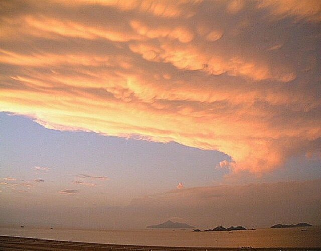
圖 15: 照片在機場氣象所於二零零二年十月十八日拍攝
航空氣象小常識問答題 |
|||
|
1. |
飛機在以下那種天氣較容易起飛? (A) 冷天氣 (B) 暖天氣 (C) 冷暖天氣都無分別 |
4. |
蒲福氏風級最高級數是甚麼? (A) 8 (B) 10 (C) 12 |
|
2. |
高濕度對飛機性能有什麼影響? (A) 飛機性能下降 (B)飛機性能上升 (C)無影響 |
5. |
以下那種天氣系統覆蓋最大面積? (A)龍捲風 (B)強烈的雷暴 (C)颱風 |
|
3. |
3. 甚麼會引致下擊暴流的形成? (A)雷暴 (B)海風 (C)飛機的排氣 |
|
|
惡劣天氣
_____________________________________
黑格比為機場製造麻煩
陳世倜
大風的時候,例如當熱帶氣旋經過時,強風吹過大嶼山後可以嚴重擾亂機場附近的氣流。
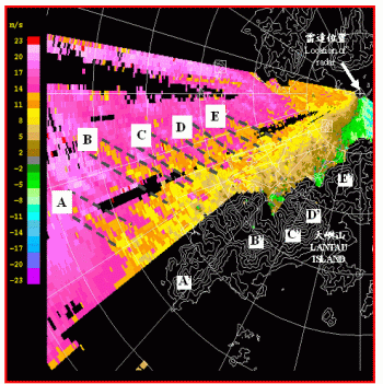
左下圖顯示在二零零二年九月十一日下午,當強烈熱帶風暴黑格比掠過香港時由機場多普勒天氣雷達所觀測到的風速變化。黑格比當時位於香港西南偏南約
一百五十公里,並向廣東西部移動(圖17)。在東南烈風之中(由圖16的粉紅色像素代表),條紋狀的較弱氣流(在圖中以虛線圍著橙色像素的A至E地帶)
與圖中以A'至E'代表的大嶼山幾個山峰的位置互相對應。
當飛機經過這些風勢時強時弱的地帶,會遇上最高達每小時三十海里
(每小時五十六公里)的逆風變化。當天有超過二十多架飛機第一次降落都不成功,需要復飛,其中大部份報告遇到低空風切變。
|
|
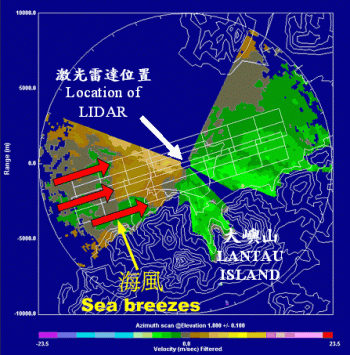
首次拍攝「海風引起的風切變」
陳世倜
海風是引起風切變的原因之一。隨著機場安裝了一套激光雷達,現在可以更容易探測到海風的出現。
圖18 顯示激光雷達觀測到發生於二零零二年八月二十一日接近中午時份海風開始形成的情況,圖中的綠色像素顯示從西面移近的海風出現於自西向東跑道
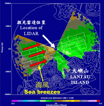
降落區。這些綠色像素代表風吹向激光雷達,而棕色像素則代表風離激光雷達(盛行東風)。海風穩定地向東移動,在正午時份到達赤鱲角的西部(圖19)。
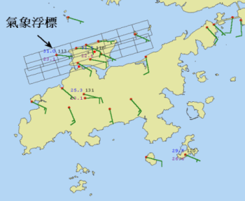
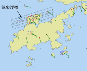
機場附近自動氣象站的觀測証實了海風前進的過程。圖20 顯示接近中午時份,機場及附近範圍普遍吹東至東南風。到正午十二時,機場西面的浮標氣象站顯示風向已經轉為西北偏西(圖 21),表示海風前沿已越過該氣象站。就是這一刻,有一班由曼谷來港的飛機在剛著陸前飛越海風前沿,機師報告遇上顯著的風切變。當日天文台在海風來臨前已事先發出風切變預警。
|
|
||||
|
|
Microburst and windshear in Hong Kong
(This article is reproduced from Flyleaf - Issue 42 with the permission from HKAOA/ HKALPA and Captain Chris Kempis)
「香港的微下擊暴流及風切變」- 轉載自 Flyleaf - Issue 42 (只以英文發表)
This discussion has been written in the wake of articles on the subject published in two Cathay Pacific magazines, namely Crews News and Kai Talk. Both articles contain useful, pertinent information and are worth taking the time to read. Kai Talk also carries an article on the Virgin Atlantic windshear incident at Chek Lap Kok (CLK) last summer. The following discussion is intended to supplement these publications.
As a result we now have in place procedures (mostly memory items) and, more recently, on-board equipment. As professional aviators we know these to be essential tools of our trade.
Microbursts are typically associated with extra-tropical or temperate climates, particularly where these occur over large land masses. What is less expected is the presence of microburst type conditions in the tropical, maritime air mass that is typical in Hong Kong. Yet, these do occur and considerable effort has been expended in achieving a better understanding of these phenomena. The Hong Kong Observatory (HKO) and IFALPA have compiled a booklet titled "Windshear and Turbulence in Hong Kong," intended as guide for pilots operating into CLK. The following is an excerpt explaining "terrain-induced windshear":
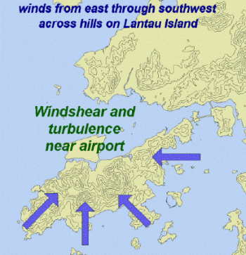
What is 'terrain-induced windshear'?
Hills disrupt the flow of air across them and hence may induce windshear and turbulence. The Hong Kong International Airport (HKIA) is located to the north of the mountainous Lantau Island, the highest peak on which is above 900 m. When winds of 15 knots or higher blow across the hills on Lantau from the east, southeast, south and southwest, windshear and turbulence may occur near the airport. Larger magnitude of windshear and turbulence is possible when the wind speed is over 30 knots.
 |
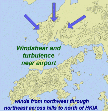 |
While winds of 20 knots or higher come from the northwest through northeast sectors across the hills to the north of HKIA, windshear and turbulence may also occur near the airport, although much less frequently.
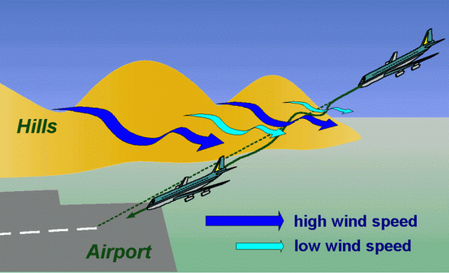
On windy occasions such as the approach of a tropical cyclone, air streams of high wind
speed may emerge from mountain gaps. Lying between these high-speed air streams are air streams of lower wind speed. Aircraft traversing
through alternating high-speed and low-speed air streams may encounter headwind losses and gains at different locations along the approach
and departure corridors.
In particular, if an aircraft flies from a low-speed air stream to a high-speed air stream, it may
experience a large headwind gain leading to a lift of the aircraft. If the aircraft moves from a high-speed air stream to a low-speed
air stream, it may experience a large headwind loss resulting in a sinking motion. This sinking occurs irrespective of whether there
is accompanying precipitation or not.
Apart from windy situations, windshear may also occur over the airport in lighter wind
conditions when the atmosphere is stable (e.g. presence of a low-level tempeature inversion). In fact, windshear has been known to occur
when winds of less than 15 knots blow across the hills on Lantau Island in the spring months.
| |
Due to the sporadic and transient characteristics of windshear, a wind speed loss/gain may not necessarily be followed/preceded by a wind speed gain/loss. Some aircraft may experience windshear and/or turbulence, while others do not, although the weather conditions are broadly the same. |
| |
Windshear and turbulence are, on average, more significant on the southern runway because of the closeness to the hills of Lantau Island. |
| |
Terrain-induced windshear does not necessarily occur in rain. As a matter of fact, many of the terrain-induced windshear reports received from aircraft flying into or out of HKIA are not associated with precipitation. |
| |
While terrain-induced windshear is not caused by a "conventional microburst", the headwind loss and the sink that it brings to an aircraft may be comparable to that of a "conventional" microburst. |
A major tool used in researching the above mentioned phenomena is the Terminal Doppler Weather Radar (TDWR). The primary role of this instrument is to detect local wind conditions that lead to windshear and microbursts and, as such, it forms an essential part of the Windshear and Turbulence Warning System (WTWS). (See Spring 2002 issue of The Flyleaf for detail on the WTWS). The Kai Talk article by meteorologists from the HKO explains some of the operations of the TDWR as well as mountain wave flow and windshear. Below is a typical TDWR display showing the "spokes" or high speed airstreams (blue) that flow out from gaps on Lantau during southerly wind conditions. Notice the lower speed airstreams (green/dark green) that are interspersed between them:
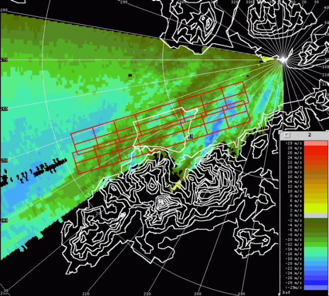
Figure 22: 10:24 hrs UTC TDWR wind velocities
Note: Blue to green indicates varying wind speeds towards radar and colors yellow to red away from radar.
So, what have we learned from the past four years of operations at CLK? Crew and ATC awareness of the potential hazards have increased
with operational exposure. The HKO is refining the calibration and algorithms for the TDWR. More importantly though, knowledge and
training are the most effective tools and they tell us that avoidance is by far the best strategy. In fact, Flight Operations management
has come out in print in both newsletters and NTCs with the clear message: Avoid! Do not take off or make/continue an approach if
a microburst alert is in force (as broadcast on ATIS or transmitted by ATC). Should an un-forecast microburst be encountered, it will
present itself as severe windshear. Follow SOPs and carry out the manoeuvre without hesitation and to the best of your ability.
On board detection systems may or may not recognize the conditions as the systems generally only operate below 1500ft RA.
(The FMGEC's did not detect windshear on the 2nd approach in the Virgin Atlantic incident). Finally, do not limit your awareness of this
phenomenon to Hong Kong. Narita 16/34 is another example of an approach in our network that is affected by windshear.
Pay close attention to METARs, ATIS, SIGMETs, Port Pages, ATC and PIREPs and form as accurate a mental picture as possible when
planning your approach or departure. Then, as stated previously, follow SOPs and training.
For more information on microbursts as well as the windshear and turbulence detection equipment in use in Hong Kong,
log on to the HKO Website at: http://www.weather.gov.hk/.
接觸客戶
_____________________________________
熱帶氣旋簡報會
劉心怡
為航空交通管制及香港機場管理局的人員作熱身,迎接熱帶氣旋季節的來臨,天文台在二零零二年五月舉辦了五場簡報會。 簡報會主要介紹熱帶氣旋帶來的天氣及風切變,參加簡報會的總人數接近一百八十位。
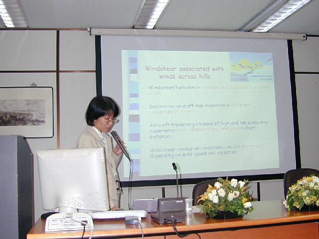
圖 23: 劉心怡正向航空交通管制及機場管理局的人員進行簡報
圖 24: 航空交通管制及機場管理局的人員積極參加討論
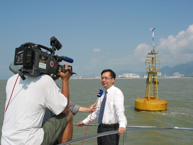
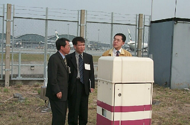
浮標初露頭角
天文台的李本瀅在二零零二年八月二十二日接受傳媒的採訪(下圖),介紹了在香港第一個建立的浮標氣象站, 該氣象站負責監測機場以西的天氣情況。當日有超過十多個傳媒機構派記者參與採訪。
機場氣象所
_____________________________________
定期演習
迅速應變
陳家強 (機電工程署)
二零零二年七月初的一個風和日麗的早上,機電工程署駐機場當值人員突然接到天文台的報告,指有一枝風桅受到嚴重破壞, 需要即時更換。機電工程署同事立即調動人手、車輛及工具,協助天文台在一小時內把備用風桅運到受影響的地點,並把桅豎起。在兩個部門同事的努力合作 下,氣象觀測能迅速回復正常。
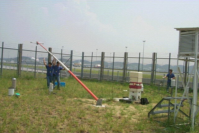
圖 25: 機電署員工正趕緊把備用風桅豎起
其實上述並不是一個真實個案,它只是香港天文台和機電工程署合作舉行的定期演習,目的是讓兩個部門的同事能熟習換桅程序,
以確保當有風桅真的受到破壞時,可以在最短時間內把風桅回復正常。機電工程署的註冊安全主任亦在當日替是項工作進行評估,使所有同事能在安全的環境
下工作。
機電工程署自赤鱲角機場啟用以來,為天文台航空氣象設施的機械、電力和冷氣系統提供一站式操作及維修服務。兩個部門的同事一直合作無間,確保儀器能夠順利運作。
雷電交擊
二零零二年八月二日,機場直接被雷電擊中。當日黃昏,與位於南海北部的一個低壓區有關的雷雨影響香港。該低壓區於翌日發展為一熱帶低氣壓, 並命名為北冕。照片由袁仲昇先生在機場氣象所利用ISO-100底片、長曝光時間及F16光圈拍攝。
會議及探訪
_____________________________________
參與更多國際事務
李本瀅
隨著天文台在航空氣象工作方面獲得更多的認同,在二零零二年的國際舞台上,天文台扮演了一個更重要的角色。 以下兩位同事最近分別成為世界氣象組織及國際民用航空組織屬下工作小組的主席:
| a) | 高級科學主任劉心怡小姐成為世界氣象組織航空氣象委員會屬下的航空氣象培訓、環境及新發展 (TREND) 工作小組中的聯合主席; |
| b) | 高級科學主任岑智明先生成為亞太區的世界區域預報系統 (WAFS) 過渡工作小組的主席。 |
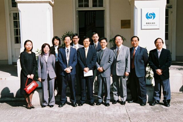
民航處探訪天文台
|
圖 26: |
署理民航處處長羅祟文先生(右四)和他的同事在二零零二年十一月六日探訪天文台,受到天文台台長林鴻鋆博士(前右五)熱烈歡迎 |
拜訪民航處及國泰航空公司
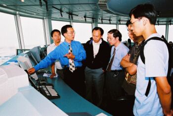
香港天文台「預報員應用氣象學」課程的學員於二零零二年七月四日拜訪了民航處及國泰航空公司,並聆聽有關業務的簡報。
 |
 |
| 圖 27: 民航處同事向天文台學員介紹空中交通管制塔的運作 | 圖 28: 國泰航空公司職員向天文台學員介紹航班的運作 |
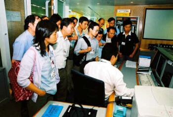
中國氣象局及韓國氣象廳到訪
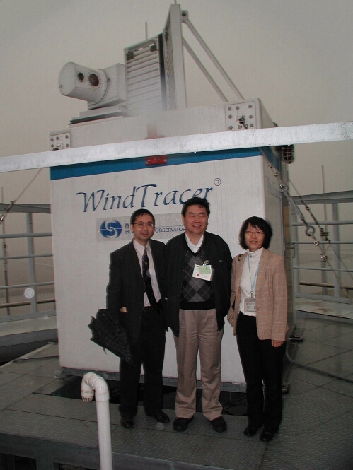
圖 29: 中國氣象局代表團於二零零二年十二月探訪天文台。 副局長李黃先生與天文台的李本瀅及劉心怡於激光雷達前留影
 |
||
|
民航總局空管局到訪
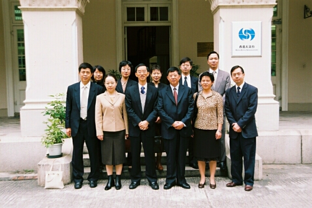
| 圖 31: | 中國民用航空總局空中交通管理局(空管局)代表團在陳海鞠局長(前排右三)及氣象處周建華處長(左二)帶領下,於二零零二年十二月訪問天文台並參加航空氣象高層管理研討會 |
人與事
_________________________________
研究助理的工作
黃偉鵬
在城市大學的計算數學系畢業後,我在機緣巧合之下進入了天文台的航空氣象服務科當研究助理。不經不覺已在這崗位工作了一年
多。我主要的工作是負責開發和改進機場氣象所的電腦程式, 讓航空天氣預報員即時得到跑道上的氣象訊息。最初在這裡工作很不習慣, 因為要面對新
環境及新事物,經過上司的循循善誘和同事們的熱心幫助,我終於能慢慢適應下來。
這份工作對我來說, 覺得最難得的是能學以致用 -
在大學修讀過的一些數學方法竟然能夠應用在氣象上, 蠻有趣噢!在這裡不但令我有很多實習編寫電腦程式的機會,更豐富了我對天氣及航空氣象的知識。
希望未來我能夠在天文台作出更多的貢獻!
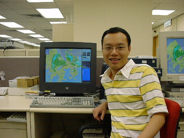
圖 32: 黃偉鵬在測試機場氣象所的電腦程式
暑期實習
陳海華
今年的暑假很高興能夠到香港天文台當了兩個多月的暑期實習工作,期間我體驗到許多新鮮的事物。從前一直以為天文台只做
天氣預報的工作,當上了暑期生後才知道他們的工作是那麼多元化。
我的暑期工作是幫助編寫電腦程式,以便進行風切變及湍流的紀錄及研究。雖然在學校編寫的程式比實習時要來得複雜,但就是少了那一份嚴謹。
在學校的功課可以有錯誤,大不了就是成績表上少了一、兩分。但工作上對應用的程式要求非常嚴格,一個錯誤就可以令用者大惑不解,引來一連串的問題。
實習期間,天文台安排了我們眾暑期生結伴作一天旅行。那天很高興能夠親身到大帽山參觀,沒想到大帽山頂上這座大型又「奇特」的建築物原來
就是天文台的氣象雷達站。另外,我們又在天文台總部見識到超級電腦和銫原子鐘,真是大開眼界。
在天文台工作,使我獲得許多寶貴的經驗,
對我未來的工作有很大的幫助。畢業後能在天文台工作也是不錯的選擇!
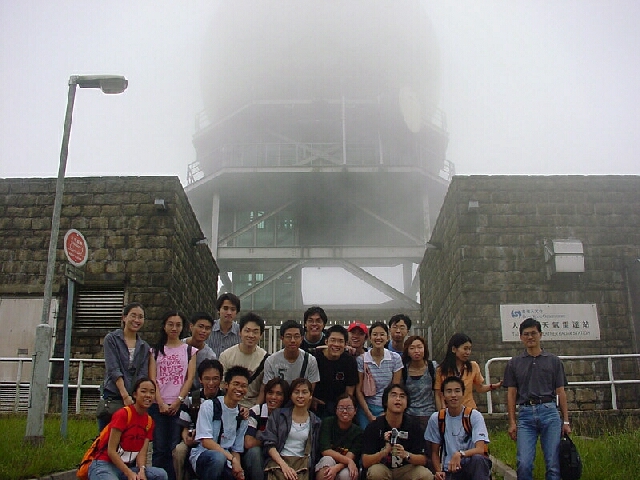
圖 33: 筆者(後左八)與眾暑期生參觀大帽山天文台氣象雷達站
|
電話及傳真號碼
Telephone and Fax Numbers |
|
|
查詢飛行氣象文件 |
(852) 2910 6922 |
|
機場氣象所主管 |
(852) 2910 6300 (852) 2922 5805 |
|
當值航空預報員 傳真 Fax |
(852)2910 6920 (852) 2910 0080 |
|
打電話問天氣 |
(852) 187 8200 |
|
查詢資料電話系統 |
(852) 2926 1133 |
|
天文台網頁
Hong Kong Observatory Home Page |
|
|
航空氣象服務網頁
Web Page for Aviation Weather Services |
|
|
http://www.weather.gov.hk/aviation |
|
|
是期編輯 蘇志權
Editor this issue C.K. So |
香港天文台:香港九龍彌敦道134A 電郵 Email:mailbox@hko.gov.hk
Hong Kong Observatory:134A Nathan Road, Kowloon, Hong Kong