Background Information
El Niño and La Niña refer to the natural climate phenomena of abnormal warming and cooling, respectively, of sea surface temperatures over the central and eastern equatorial Pacific Ocean, which subsequently affect the global atmospheric circulation. (Definition of El Niño and La Niña event)
El Niño usually peaks around Christmas, hence the name of the phenomenon (Spanish for "the little boy" or "the Christ Child"). It recurs every few years, lasting 12 months or so. La Niña, "the little girl" in Spanish, occurs less frequently but lasts longer compared with El Niño.
Under normal atmospheric and oceanic conditions (i.e. without El Niño or La Niña, also known as the ENSO-neutral conditions), trade winds over the equatorial Pacific pile up warm surface water to the east of Indonesia. Warm water drives air to rise. Part of the air mass moves eastward aloft and descends over the eastern equatorial Pacific Ocean, forming a feedback loop called the Walker Circulation (Figure 1).
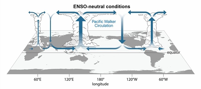
Figure 1 ENSO-neutral conditions and Walker Circulation
During El Niño, trade winds over the equatorial Pacific are weaker than normal. Warm surface water over the western equatorial Pacific retreats eastward, causing sea surface temperatures over the central and eastern equatorial Pacific to rise above normal. Atmospheric convection over the equatorial Pacific shifts eastward, thereby affecting the Walker Circulation (Figure 2).
Figure 2 El Niño conditions. (Red: Sea surface temperature is higher than normal; Blue: Sea surface temperature is relatively lower)
During La Niña, trade winds over the equatorial Pacific are stronger than normal. Warm surface water of the ocean is pushed further west. Convection over the ocean and the Walker Circulation shift accordingly (Figure 3).
Figure 3 La Niña conditions. (Blue: Sea surface temperature is lower than normal; Red: Sea surface temperature is relatively higher)
Another phenomenon, the Southern Oscillation, is closely related to El Niño and La Niña. The Southern Oscillation is an east-west balancing movement of air masses between the Pacific and the Indo-Australian areas. It is roughly synchronised and associated with typical wind patterns of El Niño and La Niña. The oscillation is measured by the Southern Oscillation Index (SOI), the difference of sea level atmospheric pressures between Tahiti and Darwin.
El Niño and La Niña are the oceanic components while the Southern Oscillation is the atmospheric counterpart. This combination gives rise to the term El Niño-Southern Oscillation (ENSO). In general, the SOI is negative during El Niño and positive during La Niña. The status of ENSO is commonly determined with reference to the sea surface temperatures across various Niño regions (Figure 4).
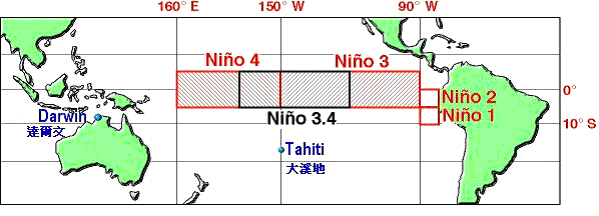 Figure 4 Graphical depiction of the four Niño regions and the location of Tahiti and Darwin for SOI Figure 4 Graphical depiction of the four Niño regions and the location of Tahiti and Darwin for SOI
Definition of El Niño and La Niña Event
The Observatory defines El Niño (La Niña) event based on the sea surface temperature (SST) anomaly index of the composite Niño region, i.e. Niño 1 to 4 region (see Figure 4). An El Niño (A La Niña) event is defined when
(i) the SST anomaly index maintains at +0.5℃ or above (-0.5℃ or below) for at least 5 to 6 months; or
(ii) the SST anomaly index remains at +0.5℃ or above (-0.5℃ or below) for 5 consecutive months and the sum of anomaly reaches +4.0℃ or above (-4.0℃ or below).
|

