Local Weather
 Weather Forecast
 Weather Warnings
 Weather for Fishermen
 Weather for Marine
 Weather for Aviation
 Weather Monitoring Imagery
 GIS Weather Service
 Tropical Cyclone
 China Weather
 World Weather
 Climate Information Service
 Warnings & Signals Database
 Statistics of Special Weather Events
 Monthly Weather Summary
 Climate Change
 El Nino and La Nina
 Earthquakes
 Tsunamis
 Tide
Tide Geomagnetism
 Space Weather
 Weather Information for Astronomical Observation
 Interactive Sun Path Diagram
 Astronomical Data
 Interesting Astronomical Phenomena
 Time Services
 Calendar
 Almanac
 Real time Radiation level in Hong Kong
 Understanding Radiation
 Radiation Monitoring, Assessment and Protection
 Environmental Radiation Monitoring Programme
 Daya Bay Contingency Plan
 Related Sites
 Schools
 Travel
 Sports
 Outdoor Photography
 CWOS
CWOS Senior Citizens
 Stargazers
 FoOb
FoOb My Little Observatory
 Educational Resources
 A Tour of Tropical Cyclones
 Cloud Appreciation by Dr Tin
 International Cloud Atlas
 Guided Tour
 Courses and Activities for the Public
 Subscription of e-Bulletins
 Research Forum
 Publications
 International Atomic Energy Agency
 Regional Specialized Meteorological Centre for nowcasting
 Asian Aviation Meteorological Center
 Social Media
 Press Releases
 What's New
 HKO Updates
 LegCo Questions and Answers
 Weather Chit Chat
 Observatory's Blog
 Weather On-Air
 Cool Met Stuff
 Central Briefing
 Tropical Cyclone Report Broadcast
 Observatory's News
 Vacancies
 Tender Notices
 Apps
Apps Personalized Website
 Weather Wizard
 Weather Information in Text
 Weather Information in RSS
 Audio Web Page
 Forms
Forms Open Data
 HKO Corporate Video
 Vision and Mission
 Organizational Structure
 Quality Management
 Hong Kong Observatory – The Facts
 Hong Kong Observatory 2023
 Our Services
 Programme Areas of the Observatory
 History of the Hong Kong Observatory
 Career@HKO
 Visitors Figures
 Hong Kong Observatory Open Day 2025
The Weather of March 2015
2 April 2015
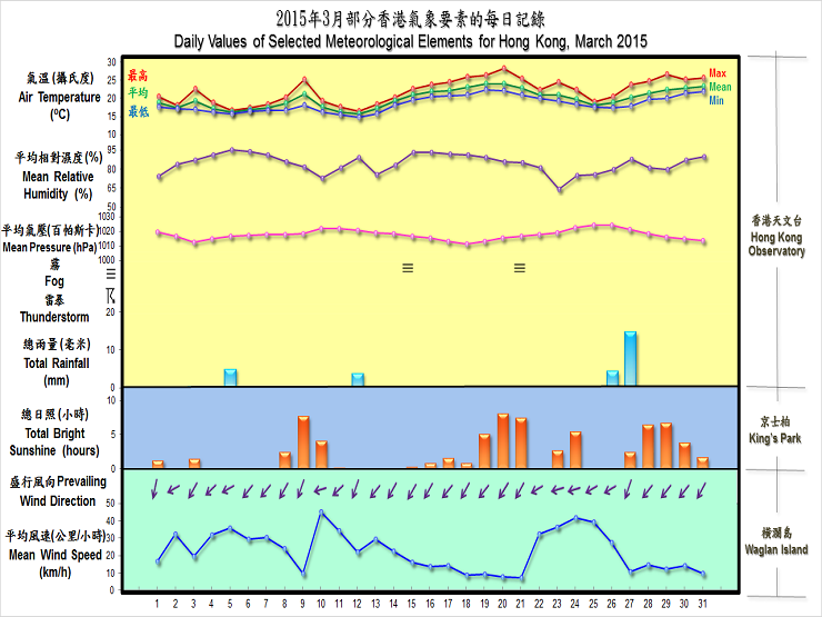
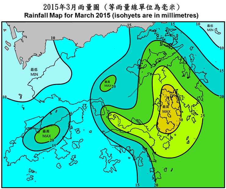
With a maritime airstream dominating over the coast of Guangdong during the latter half of the month, the weather of Hong Kong in March 2015 was warmer than usual. The monthly mean temperature was 19.9 degrees, 0.8 degrees higher than the normal figure of 19.1 degrees. The total rainfall in the month was 28.4 millimetres, only about 35 percent of the normal figure of 82.2 millimetres. The accumulated rainfall of 102.1 millimetres since 1 January was about 37 percent below the normal figure of 161.3 millimetres for the same period.
A cold front over southern China moved across the coastal areas of Guangdong on the first day of the month and the strengthening of an easterly airstream brought cooler weather the next day. Another replenishment of the northeast monsoon on 4 and 5 March brought windy and even cooler conditions to Hong Kong, and the weather remained cloudy with light rain and mist patches till 8 March.
Following a lull in the northeast monsoon that brought a warm and sunny day on 9 March, easterly winds strengthened again the next day as another replenishment of the northeast monsoon reached the coast of Guangdong. The weather became significantly cooler with light rain patches on 10-13 March. Temperatures at the Observatory fell to a minimum of 14.8 degrees on 12 March, the lowest of the month.
As the northeast monsoon subsided, it was gradually replaced by a warmer maritime airstream on 14 and 15 March. Local weather turned increasingly humid with lingering clouds, mist and fog. As temperatures continued to rise, clouds finally dispersed during the day for some sunshine to break through on 19 March. Fine weather then prevailed in the next couple of days and temperatures at the Observatory climbed to a maximum of 28.3 degrees on 20 March, the highest of the month.
With easterly winds strengthening and the northeast monsoon returning to the coast of Guangdong, the weather turned generally cloudy and windy with light rain patches from 22 to 26 March. After a rainy morning on 27 March, sunny intervals appeared in the afternoon as warm maritime air set in over the coast of Guangdong. Despite some coastal mist, clouds thinned out during the day with sunny periods coming through towards the end of the month.
Two tropical cyclones occurred over the South China Sea and the western North Pacific in the month.
Details of issuance and cancellation of various warnings/signals in the month are summarized in Tables 1.1 to 1.2. Monthly meteorological figures and departures from normal for March are tabulated in Table 2.
Warnings and Signals issued in March 2015
Table 1.1 Strong Monsoon Signal
| Beginning Time | Ending Time | ||
|---|---|---|---|
| Day/Month | HKT | Day/Month | HKT |
| 5 / 3 | 0330 | 6 / 3 | 0545 |
| 10 / 3 | 0745 | 11 / 3 | 0745 |
| 23 / 3 | 0315 | 23 / 3 | 1345 |
| 24 / 3 | 2245 | 26 / 3 | 0745 |
Table 1.2 Fire Danger Warnings
| Colour | Beginning Time | Ending Time | ||
|---|---|---|---|---|
| Day/Month | HKT | Day/Month | HKT | |
| Yellow | 1 / 3 | 0600 | 1 / 3 | 2315 |
| Yellow | 22 / 3 | 1200 | 22 / 3 | 2345 |
| Yellow | 29 / 3 | 0600 | 29 / 3 | 2145 |
Table 2 Figures and Departures from Normal - March 2015
| Meteorological Element | Figure of the Month | Departure from Normal* |
|---|---|---|
| Mean Daily Maximum Air Temperature | 22.0 degrees C | 0.6 degree above normal |
| Mean Air Temperature | 19.9 degrees C | 0.8 degree above normal |
| Mean Daily Minimum Air Temperature | 18.5 degrees C | 1.3 degrees above normal |
| Mean Dew Point Temperature | 17.1 degrees C | 1.4 degrees above normal |
| Mean Relative Humidity | 85 % | 3 % above normal |
| Mean Cloud Amount | 83 % | 4 % above normal |
| Total Rainfall | 28.4 mm | 53.8 mm below normal |
| Number of hours of Reduced VisibilityΔ | 72 hours | 47.2 hours below normal§ |
| Total Bright Sunshine Duration | 69.9 hours | 20.9 hours below normal |
| Mean Daily Global Solar Radiation | 10.12 Megajoule / square metre | 0.16 Megajoule above normal |
| Total Evaporation | 69.2 mm | 1.3 mm below normal |
| Remarks : | All measurements were made at the Hong Kong Observatory except sunshine, solar radiation and evaporation which were recorded at King's Park Meteorological Station and visibility which was observed at the Hong Kong International Airport. |
| Δ |
The visibility readings at the Hong Kong International Airport are based on hourly observations by professional meteorological observers in 2004 and before, and average readings over the 10-minute period before the clock hour of the visibility meter near the middle of the south runway from 2005 onwards. The change of the data source in 2005 is an improvement of the visibility assessment using instrumented observations following the international trend. |
* Departure from 1981 - 2010 climatological normal, except for number of hours of reduced visibility |
|
§ Departure from mean value between 1997 and 2014 |
|
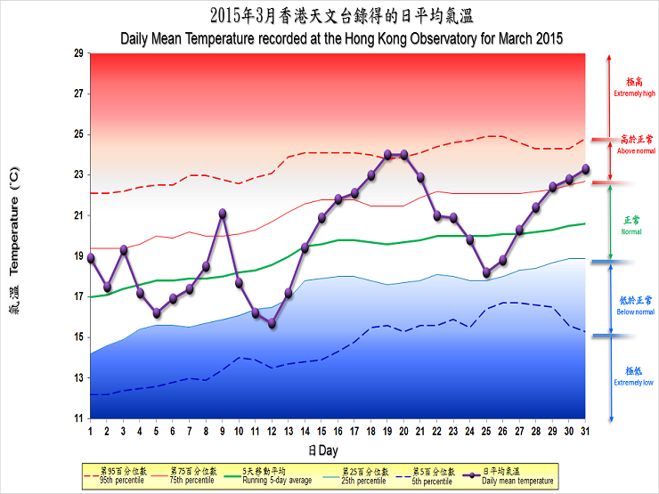
| Remarks : | Extremely high: above 95th percentile Above normal: between 75th and 95th percentile Normal: between 25th and 75th percentile Below normal: between 5th and 25th percentile Extremely low: below 5th percentile Percentile and 5-day running average values are computed based on the data from 1981 to 2010 |
Extract of Meteorological Observations in Hong Kong for March 2015